| North Fork Eel River | |
|---|---|
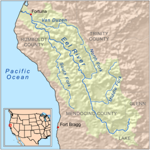
 Map of the Eel River drainage basin, including the North Fork Eel River | |
| Location | |
| Country | United States |
| State | California |
| Region | Trinity County, Mendocino County |
| Physical characteristics | |
| Source | Confluence of East and West Forks |
| • location | Six Rivers National Forest, Trinity County |
| • coordinates | 40°12′49″N 123°23′14″W / 40.21361°N 123.38722°W[1] |
| • elevation | 2,123 ft (647 m) |
| Mouth | Eel River |
• location | About 6 miles (9.7 km) north of Spyrock, Mendocino County |
• coordinates | 39°57′24″N 123°26′14″W / 39.95667°N 123.43722°W[1] |
• elevation | 574 ft (175 m)[1] |
| Length | 35.5 mi (57.1 km)[2] |
| Basin size | 286 sq mi (740 km2)[2] |
| Discharge | |
| • location | Mina, CA |
| • average | 644 cu ft/s (18.2 m3/s) |
| • minimum | 0.13 cu ft/s (0.0037 m3/s) |
| • maximum | 133,000 cu ft/s (3,800 m3/s) |
| Basin features | |
| River system | Eel River |
| Tributaries | |
| • left | Red Mountain Creek, Hulls Creek |
| • right | Wilson Creek |
| Designated | January 19, 1981 |
The North Fork Eel River is the smallest of four major tributaries of the Eel River in northwestern California in the United States. It drains a rugged wilderness area of about 286 square miles (740 km2) [2] in the California Coast Ranges, and flows through national forests for much of its length. Very few people inhabit the relatively pristine watershed of the river; there are no operational stream gauges and only one bridge (Mina Road) that crosses the river, near the boundary between Trinity and Mendocino Counties.[3]
- ^ a b c "North Fork Eel River". Geographic Names Information System. United States Geological Survey, United States Department of the Interior. 1981-01-19. Retrieved 2010-06-18.
- ^ a b c "Steelhead/rainbow trout resources of the North Fork Eel River" (PDF). Center for Ecosystem Management and Restoration. Retrieved 2010-06-18.
- ^ Graziani, Virginia (2010-05-27). "Eel River tour highlights support for Potter Valley diversion – Humboldt supes call for Eel/Russian Commission meeting". Redwood Times. Retrieved 2010-06-18.