| North Fork Pacheco Creek | |
|---|---|
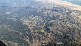
 Aerial Photo of North Fork Pacheco Creek Watershed in the Diablo Range of Northern California | |
 | |
| Location | |
| Country | United States |
| State | California |
| Region | Santa Clara County |
| Physical characteristics | |
| Source | |
| • location | Henry Coe State Park |
| • coordinates | 37°11′17″N 121°25′42″W / 37.18806°N 121.42833°W[1] |
| • elevation | 2,360 ft (720 m) |
| Mouth | Confluence of North Fork Pacheco Creek and South Fork Pacheco Creek |
• location | 16.5 mi (27 km) east of Gilroy |
• coordinates | 37°02′42″N 121°17′23″W / 37.04500°N 121.28972°W[1] |
• elevation | 430 ft (130 m) |
| Basin features | |
| Tributaries | |
| • left | Mississippi Creek, East Fork Pacheco Creek |

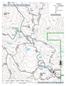
North Fork Pacheco Creek is a 19 miles (31 km) tributary stream of Pacheco Creek, in Santa Clara County, California. Originally it was considered the upper reach of Pacheco Creek.[2] Its source is at an elevation of 2,360 feet (720 m) at 37°11′17″N 121°25′42″W / 37.18806°N 121.42833°W on a mountain side in Henry W. Coe State Park and is the headwaters of the Pajaro River watershed.[3]