| North Fork Smoky Hill River | |
|---|---|
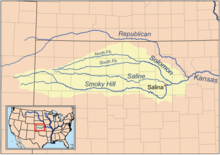
 Map of the Smoky Hill drainage basin | |
| Location | |
| Country | United States |
| State | Colorado, Kansas |
| Physical characteristics | |
| Source | |
| • location | Cheyenne County, Colorado |
| • coordinates | 39°02′06″N 102°48′28″W / 39.03500°N 102.80778°W |
| • elevation | 4,811 ft (1,466 m) |
| Mouth | Smoky Hill River |
• location | Logan County, Kansas |
• coordinates | 38°55′13″N 101°16′51″W / 38.92028°N 101.28083°W[1] |
• elevation | 2,940 ft (900 m) |
| Length | 195 mi (314 km) |
| Basin size | 759 sq mi (1,970 km2) |
| Basin features | |
| Watersheds | North Fork Smoky Hill-Smoky Hill-Kansas-Missouri-Mississippi |
The North Fork Smoky Hill River is a river in the central Great Plains of North America. A tributary of the Smoky Hill River, it flows from eastern Colorado into western Kansas.[2][3]
- ^ "North Fork Smoky Hill River". Geographic Names Information System. United States Geological Survey, United States Department of the Interior. Retrieved 2011-02-01.
- ^ Cite error: The named reference
COMapwas invoked but never defined (see the help page). - ^ Cite error: The named reference
KDOTwas invoked but never defined (see the help page).