| North Island Fault System | |
|---|---|
| North Island Shear Belt, NIFS, North Island Dextral Fault Belt, | |
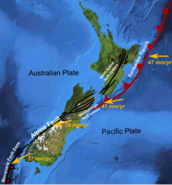
 Major active fault zones of New Zealand for orientation (North Island Fault System is labelled) and to show variation in displacement vector of Pacific Plate relative to the Kermadec Plate and Australian Plate along the boundary. The Kermadec Trench label would better read Hikurangi Trough at this position. The Kermadec Plate is not labelled but lies between the labels of the North Island Fault System and the Kermadec Trench in the picture. | |
 Main active strands of the North Island Fault System | |
| Etymology | North Island |
| Country | New Zealand |
| Region | North Island |
| Characteristics | |
| Length | 200 km (120 mi) |
| Displacement | 1 cm (0.39 in)/yr |
| Tectonics | |
| Plate | Australian |
| Status | Active |
| Type | strike-slip |
| Movement | Mw8.2 |
| Age | Miocene-Holocene |
| New Zealand geology database (includes faults) | |
The North Island Fault System (NIFS) (also known as North Island Dextral Fault Belt or North Island Shear Belt[1]) is a set of southwest–northeast trending seismically-active faults in the North Island of New Zealand that carry much of the dextral (right lateral) strike-slip component of the oblique convergence of the Pacific Plate with the Australian Plate. However despite at least 3 km (1.9 mi) of uplift of the axial ranges in the middle regions of the fault system during the last 10 million years most of the shortening on this part of the Hikurangi Margin is accommodated by subduction.[2]
The faults include the Wairarapa Fault and Wellington Fault to the southwest, the Ruahine and Mohaka Faults in the central section and the Waimana, Waiotahi, Whakatane and Waiohau Faults to the northeast. Most of the fault system consists of dextral strike-slip faults, although towards its northeastern end the trend swings to more S-N trend and the faults become mainly oblique normal in sense as the zone intersects with the Taupō Rift. This fault zone accommodates up to 1 cm/year (0.39 in/year) of strike-slip displacement.[3]
- ^ Taylor, Susanna K. A Long Timescale High-Resolution Fault Activity History of the Whakatane Graben, Bay of Plenty, New Zealand (PhD thesis Graduate School of the Southampton Oceanography Centre) (PDF) (Thesis). Retrieved 2023-04-04.
- ^ Bland, KJ; Nicol, A; Kamp, PJ; Nelson, CS (3 April 2019). "Stratigraphic constraints on the late Miocene–Pleistocene evolution of the North Island Fault System and axial ranges in the central Hikurangi subduction margin, New Zealand". New Zealand Journal of Geology and Geophysics. 62 (2): 248–272. Bibcode:2019NZJGG..62..248B. doi:10.1080/00288306.2018.1545675. S2CID 133654174.
- ^ Mouslopoulou, V.; Nicol, A.; Little, T.A.; Begg J.A. (2009). "Palaeoearthquake surface rupture in a transition zone from strike-slip to oblique-normal slip and its implications to seismic hazard, North Island Fault System, New Zealand". In Reicherter K., Michetti A.M. & Silva P.G. (ed.). Palaeoseismology: historical and prehistorical records of earthquake ground effects for seismic hazard assessment. Special Publications. Vol. 316. London: Geological Society. pp. 269–292. ISBN 978-1-86239-276-2.