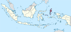
North Maluku
Maluku Utara | |
|---|---|
| Province of North Maluku Provinsi Maluku Utara | |
| Nickname(s): | |
| Motto(s): Marimoi Ngone Futuru (Ternate) United we stand | |
 | |
| Coordinates: 0°47′N 127°22′E / 0.783°N 127.367°E | |
| Capital | Sofifi |
| Largest city | Ternate |
| Government | |
| • Body | North Maluku Provincial Government |
| • Governor | Al Yasin Ali (acting) |
| • Vice Governor | Vacant |
| Area | |
• Total | 34,138.36 km2 (13,180.89 sq mi) |
| • Rank | 27th in Indonesia |
| Highest elevation (Buku Sibela) | 2,111 m (6,926 ft) |
| Population (mid 2023 estimate)[1] | |
• Total | 1,328,594 |
| • Density | 39/km2 (100/sq mi) |
| Demographics | |
| • Religion | Islam (74.28%), Protestantism (24.9%), Catholicism (0.52%) |
| • Languages | Indonesian (official), Ternate Malay (lingua franca) Ternate (regional), Galela (regional), Tobelo (regional) |
| • Ethnicity | makian (12,78%) Galela (9,70%) Ternate (9,40%) Tobelo (8,51%) Tidore (7,76%) Sula (6,98%) Buton (5,67%) Javanese (4,12%) Sangir (3,04%) Loloda (2,61%) Tabaru (2,24%) Kao (2,15%) Bugis (2,01%) Patani (1,84%) Bajo (1,73%) Chinese (0,22%) other ethnics (21,24%)[2] |
| Time zone | UTC+09 (Indonesia Eastern Time) |
| ISO 3166 code | ID-MU |
| HDI | |
| Website | malutprov.go.id |
North Maluku (Indonesian: Maluku Utara) is a province of Indonesia. It covers the northern part of the Maluku Islands, bordering the Pacific Ocean to the north, the Halmahera Sea to the east, the Molucca Sea to the west, and the Seram Sea to the south. It shares maritime borders with North Sulawesi, Southeast Sulawesi and Central Sulawesi to the west, Maluku to the south, Southwest Papua to the east, and Palau and the Philippines to the north. The provincial capital is Sofifi, mostly part of the city of Tidore Islands on the largest island of Halmahera, while the largest city is the island city of Ternate. The population of North Maluku was 1,038,087 in the 2010 census,[4] making it one of the least-populous provinces in Indonesia, but by the 2020 Census the population had risen to 1,282,937,[5] and the official estimate as at mid 2023 was 1,328,594.[1]
North Maluku was originally the centre of the four largest Islamic sultanates in the eastern Indonesian archipelago—Bacan, Jailolo, Tidore and Ternate—known as the Moloku Kië Raha (the Four Mountains of Maluku). Upon Europeans' arrival at the beginning of the 16th century, North Maluku became the site of competition between the Portuguese, Spanish and the Dutch to control trade. In the end, the Dutch emerged victorious, beginning three centuries of Dutch rule in the region. The Japanese invaded the region during World War II, and Ternate became the center of the Japanese rule of the Pacific region. Following Indonesian independence, the region became a part of the province of Maluku.
The province of North Maluku was officially established on 12 October 1999, by separation from Maluku. The island city of Ternate served as its de facto capital until 2010, when the provincial government moved to Sofifi on the mainland of Halmahera. The regional economy in North Maluku largely relies on the agricultural sector, fisheries and other types of marine products. The main commodities that support the economic pulse in North Maluku include copra, nutmeg, cloves, fisheries, gold and nickel. North Maluku's agricultural products include rice, corn, roasted sweet potatoes, beans, coconut, potatoes, nutmeg, sago, and eucalyptus.
- ^ a b Badan Pusat Statistik, Jakarta, 28 February 2024, Provinsi Maluku Utara Dalam Angka 2024 (Katalog-BPS 1102001.82)
- ^ Demography of Indonesia's Ethnicity. Institute of Southeast Asian Studies. 2015. ISBN 978-9814519878.
- ^ "Indeks Pembangunan Manusia 2024" (in Indonesian). Statistics Indonesia. 2024. Retrieved 15 November 2024.
- ^ Biro Pusat Statistik, Jakarta, 2011.
- ^ Badan Pusat Statistik, Jakarta, 2021.

