| Northeastern Congolian lowland forests | |
|---|---|
 | |
 Northeastern Congolian lowland forests | |
| Ecology | |
| Realm | Afrotropical |
| Biome | Tropical and subtropical moist broadleaf forests |
| Borders | |
| Geography | |
| Area | 512,304 km2 (197,802 sq mi) |
| Countries | |
| Elevation | 600 m to 1,000 m |
| Coordinates | 2°12′N 25°42′E / 2.2°N 25.7°E |
| Rivers | Bounded by Uele River, Congo River, Elila River, and Bomu River[1] |
| Conservation | |
| Conservation status | vulnerable |
| Global 200 | yes |
| Protected | 54,712 km2 (11%)[2] |
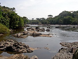
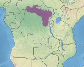
The Northeastern Congolian lowland forests (French: Forêts de plaine du nord-est du Congo) is a tropical moist broadleaf forest ecoregion that spans the Democratic Republic of the Congo and the Central African Republic.[3][4][5]
- ^ Blom, Allard; Schipper, Jan. "Western: Cameroon, Central African Republic, Gabon, and Republic of the Congo". World Wildlife Fund. Archived from the original on 2017-09-03. Retrieved 2017-08-30.
- ^ Eric Dinerstein, David Olson, et al. (2017). An Ecoregion-Based Approach to Protecting Half the Terrestrial Realm, BioScience, Volume 67, Issue 6, June 2017, Pages 534–545; Supplemental material 2 table S1b. [1]
- ^ "Map of Ecoregions 2017". Resolve. Retrieved August 20, 2021.
- ^ "Northeastern Congolian lowland forests". Digital Observatory for Protected Areas. Retrieved 9 May 2022.
- ^ "Northeastern Congolian lowland forests". The Encyclopedia of Earth. Retrieved August 20, 2021.