This article needs additional citations for verification. (February 2012) |
Northeastern Manitoulin and the Islands | |
|---|---|
| Town of Northeastern Manitoulin and the Islands | |
 | |
| Coordinates: 45°58′N 81°56′W / 45.967°N 81.933°W | |
| Country | Canada |
| Province | Ontario |
| District | Manitoulin |
| Established | January 1, 1998 |
| Government | |
| • Type | Town |
| • Mayor | Alan MacNevin |
| • MP | Carol Hughes (NDP) |
| • MPP | Michael Mantha (NDP) |
| Area | |
| • Land | 495.68 km2 (191.38 sq mi) |
| Population (2011)[1] | |
| • Total | 2,706 |
| • Density | 5.5/km2 (14/sq mi) |
| Time zone | UTC-5 (EST) |
| • Summer (DST) | UTC-4 (EDT) |
| Postal code | P0P 1K0 |
| Area code | 705 |
| Highways | |
| Website | www.townofnemi.on.ca |
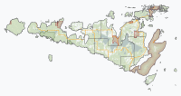
Northeastern Manitoulin and the Islands is a municipality with town status in Manitoulin District in Northeastern Ontario, Canada, approximately 30 kilometres (19 mi) south of Espanola. Its main town is Little Current, located on the northeast side of Manitoulin Island. However, its territory also includes most of the small islands surrounding Manitoulin, even those at the far western end of Manitoulin.
The town was created on January 1, 1998, by amalgamating the Town of Little Current with the Township of Howland and the unorganized small islands in Lake Huron.
It is the administrative headquarters of the Aundeck Omni Kaning First Nations band government.[1]

