Norwalk, Ohio | |
|---|---|
 Downtown Norwalk during the 2024 Total Eclipse | |
| Nickname: The Maple City[1] | |
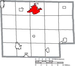
 Location of Norwalk in Huron County | |
| Coordinates: 41°14′40″N 82°36′32″W / 41.24444°N 82.60889°W | |
| Country | United States |
| State | Ohio |
| County | Huron |
| Founded | 1817 |
| Government | |
| • Mayor | David W. Light[2] |
| Area | |
• Total | 9.15 sq mi (23.69 km2) |
| • Land | 8.87 sq mi (22.96 km2) |
| • Water | 0.28 sq mi (0.73 km2) |
| Elevation | 715 ft (218 m) |
| Population (2020) | |
• Total | 17,068 |
| • Density | 1,925.32/sq mi (743.36/km2) |
| Time zone | UTC-5 (Eastern (EST)) |
| • Summer (DST) | UTC-4 (EDT) |
| ZIP code | 44857 |
| Area code(s) | 419, 567 |
| FIPS code | 39-57302[5] |
| GNIS feature ID | 1086352[4] |
| Website | http://www.norwalkoh.com/ |
Norwalk is a city in and the county seat of Huron County, Ohio, United States.[6] The population was 17,068 at the 2020 census. The city is the center of the Norwalk micropolitan area and part of the Cleveland–Akron–Canton combined statistical area. Norwalk is located approximately 10 miles (16 km) south of Lake Erie, 51 miles (82 km) west/southwest of Cleveland, 59 miles (95 km) southeast of Toledo, and 58 miles (93 km) west/northwest of Akron.
- ^ City of Norwalk
- ^ "Mayor David W. Light". City of Norwalk (Ohio). Retrieved November 3, 2020.
- ^ "ArcGIS REST Services Directory". United States Census Bureau. Retrieved September 20, 2022.
- ^ a b U.S. Geological Survey Geographic Names Information System: Norwalk, Ohio
- ^ "U.S. Census website". United States Census Bureau. Retrieved January 31, 2008.
- ^ "Find a County". National Association of Counties. Retrieved June 7, 2011.


