Norwell, Massachusetts | |
|---|---|
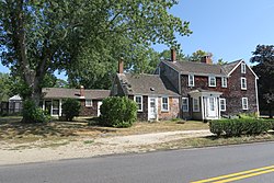
 Jacobs Farmhouse, Norwell Historical Society | |
 Location in Plymouth County, Massachusetts | |
| Coordinates: 42°09′42″N 70°47′40″W / 42.16167°N 70.79444°W | |
| Country | United States |
| State | Massachusetts |
| County | Plymouth |
| Settled | 1634 |
| Incorporated | February 14, 1849 |
| Government | |
| • Type | Open town meeting |
| • Town Administrator | Peter Morin[1] |
| • Board of Selectmen | Ellen Allen, Chair; Jason Brown, Vice Chair; Alison Demong, Clerk; Joseph Rull; Bruce Graham |
| Area | |
| • Total | 21.2 sq mi (54.8 km2) |
| • Land | 20.9 sq mi (54.1 km2) |
| • Water | 0.3 sq mi (0.8 km2) |
| Elevation | 81 ft (25 m) |
| Population (2020) | |
| • Total | 11,351 |
| • Density | 540/sq mi (210/km2) |
| Time zone | UTC-5 (Eastern) |
| • Summer (DST) | UTC-4 (Eastern) |
| ZIP Code | 02061 |
| Area code | 339/781 |
| FIPS code | 25-50145 |
| GNIS feature ID | 0618347 |
| Website | www |
Norwell is a town in Plymouth County, Massachusetts, United States. The population was 11,351 at the 2020 United States census.[2] The town's southeastern border runs along the North River.
- ^ "Town Administrator - Town of Norwell MA". www.townofnorwell.net. Retrieved May 16, 2017.
- ^ "Census - Geography Profile: Norwell town, Plymouth County, Massachusetts". United States Census Bureau. Retrieved November 6, 2021.
