This article possibly contains original research. (July 2020) |
| Norwell | |
|---|---|
| Village and civil parish | |
 | |
 Parish map | |
Location within Nottinghamshire | |
| Area | 4.71 sq mi (12.2 km2) |
| Population | 470 (2021) |
| • Density | 100/sq mi (39/km2) |
| OS grid reference | SK 7761 |
| • London | 115 mi (185 km) SSE |
| District | |
| Shire county | |
| Region | |
| Country | England |
| Sovereign state | United Kingdom |
| Settlements | Norwell Norwell Woodhouse |
| Post town | Newark |
| Postcode district | NG23 |
| Dialling code | 01636 |
| Police | Nottinghamshire |
| Fire | Nottinghamshire |
| Ambulance | East Midlands |
| UK Parliament | |
| Website | www |
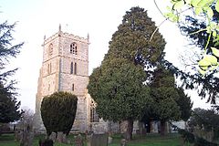
Norwell is a village and civil parish about 6 miles (9.7 km) from Newark-on-Trent, in central Nottinghamshire, England. The population (including Norwell Woodhouse) at the 2011 census was 490,[1] this declined to 470 at the 2021 census.[2] It is close to the border with Lincolnshire and the River Trent, and lies approximately 1.5 miles (2.4 km) from the A1 road and 1 mile (1.6 km) from the East Coast Main Line.
- ^ Norwell. "Neighbourhood Statistics". Office for National Statistics. Retrieved 19 January 2017.
- ^ UK Census (2021). "2021 Census Area Profile – Norwell parish (E04007931)". Nomis. Office for National Statistics. Retrieved 5 February 2024.
