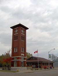
Norwich | |
|---|---|
| Township of Norwich | |
 | |
| Motto(s): Beautiful, Agricultural, Historical | |
| Coordinates: 42°59′N 80°36′W / 42.983°N 80.600°W | |
| Country | Canada |
| Province | Ontario |
| County | Oxford |
| Government | |
| • Mayor | Jim Palmer [1] |
| • Councillors | List |
| • MPs | Arpan Khanna |
| • MPPs | Ernie Hardeman |
| Area | |
| • Land | 431.27 km2 (166.51 sq mi) |
| Population (2016)[2] | |
| • Total | 11,001 |
| • Density | 25.5/km2 (66/sq mi) |
| Time zone | UTC−05:00 (EST) |
| • Summer (DST) | UTC−04:00 (EDT) |
| Postal Code | N0J 1P0, N0J 1P1, N0J 1P2 |
| Area code(s) | 519, 226, 548 |
| Website | www |
The Township of Norwich is a municipality located in Oxford County in Southwestern Ontario, Canada. At the centre of the Township of Norwich is the Town of Norwich. The preferred pronunciation of the town name is /ˈnɔːrwɪtʃ/ NOR-witch, which differs from the pronunciation /ˈnɒrɪdʒ/ NORR-ij used for the city of Norwich, England. The origin of Norwich, Ontario, is more likely Norwich in upper New York State, the area from which the pioneering families emigrated in the early 19th century, where the community was known as Norwichville.
Oxford County Road 59 (formerly Highway 59) is the major north–south highway through much of the township, including the Town of Norwich.
The local economy is largely agricultural, based on corn, soybean, and wheat production with dairy farming in the north part of the township and tobacco, vegetable, and ginseng farming to the south. Slowly, ginseng and traditional cash crops are replacing the former cash crop - tobacco, as demand shrinks.
- ^ "Township of Norwich 2018 Municipal Election Official Results". Township of Norwich. Archived from the original on 2018-12-15. Retrieved 2018-12-11.
- ^ a b Statistics Canada. 2016. Norwich, Ontario (Code 3532002) census profile. 2016 Census.
