Noto Airport 能登空港 Noto Kūkō | |||||||||||
|---|---|---|---|---|---|---|---|---|---|---|---|
 | |||||||||||
| Summary | |||||||||||
| Airport type | Public | ||||||||||
| Operator | Ministry of Transport | ||||||||||
| Location | Wajima, Ishikawa | ||||||||||
| Elevation AMSL | 718 ft / 219 m | ||||||||||
| Coordinates | 37°17′36″N 136°57′44″E / 37.29333°N 136.96222°E | ||||||||||
| Map | |||||||||||
 | |||||||||||
| Runways | |||||||||||
| |||||||||||
| Statistics (2015) | |||||||||||
| |||||||||||
Source: Japanese Ministry of Land, Infrastructure, Transport and Tourism[1] | |||||||||||
Noto Airport (能登空港, Noto Kūkō) (IATA: NTQ, ICAO: RJNW), marketed as Noto Satoyama Airport (のと里山空港, Noto Satoyama Kūkō) and also unofficially known as Wajima Airport (輪島空港, Wajima Kūkō) is a domestic airport located 6.4 NM (11.9 km; 7.4 mi) south southeast[2] of the city of Wajima on the Noto Peninsula of Ishikawa Prefecture, Japan.
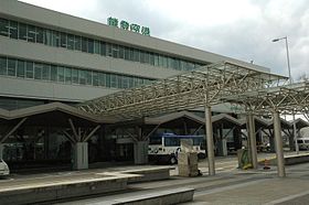
The airport is a four-story building with two jetways. It is officially designated a third class airport.
- ^ "Noto Airport" (PDF). Japanese Ministry of Land, Infrastructure, Transport and Tourism. Archived from the original (PDF) on 21 October 2016. Retrieved 7 January 2017.
- ^ AIS Japan

