You can help expand this article with text translated from the corresponding article in Czech. (January 2012) Click [show] for important translation instructions.
|
Nusle Bridge | |
|---|---|
 Nusle Bridge with Corinthia Towers hotel | |
| Coordinates | 50°03′57″N 14°25′50″E / 50.065844°N 14.430483°E |
| Carries | 6 lanes of roadway, 2 tracks of Prague Metro Line C, pedestrians |
| Crosses | Nusle Valley |
| Locale | Prague |
| Official name | Nuselský most |
| Characteristics | |
| Design | prestressed concrete hollow box haunched cantilever bridge |
| Total length | 485 metres (1,591 ft) |
| Width | 26.5 metres (87 ft) |
| Longest span | 115.5 metres (379 ft) |
| Clearance below | 42.5 metres (139 ft) |
| History | |
| Construction start | 1967 |
| Opened | 22 February 1973 |
| Location | |
 | |
Nusle Bridge (Czech: Nuselský most) is a prestressed concrete viaduct in Prague, Czech Republic. It connects Prague 2 and Prague 4, across a valley which forms part of the Nusle district. The bridge is one of the longest in the country and carries two footpaths, a multi-lane road and part of the city's metro network.
The bridge links the city center to its south-eastern districts such as Pankrác, and joins the D1 motorway leading to Brno. It is crucial to Prague's transportation network, since almost all north-south traffic flows across it.[1] Below the six-lane highway on the surface, lies part of Prague Metro Line C between I.P. Pavlova and Vyšehrad stations.
-
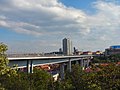 View from the north
 -
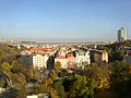
 View from the south
 -
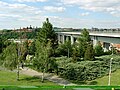
 View from the west (from Vyšehrad)
 -
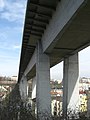 View from below


- ^ Cameron, Rob (7 November 2003). "Nusle Bridge: Concrete Giant Which Fell Victim to Politics of Cold War". Insight Central Europe. Archived from the original on 9 November 2014. Retrieved 24 January 2008.