Nut Tree Airport | |||||||||||
|---|---|---|---|---|---|---|---|---|---|---|---|
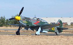
 Yak-9U at Nut Tree Airport | |||||||||||
| Summary | |||||||||||
| Airport type | Public | ||||||||||
| Owner/Operator | County of Solano | ||||||||||
| Serves | Vacaville, California | ||||||||||
| Elevation AMSL | 117 ft / 36 m | ||||||||||
| Coordinates | 38°22′40″N 121°57′42″W / 38.37778°N 121.96167°W | ||||||||||
| Website | http://www.flynuttree.com/nta/Home.html | ||||||||||
 | |||||||||||
| Runways | |||||||||||
| |||||||||||
| Statistics (2022) | |||||||||||
| |||||||||||
Nut Tree Airport (ICAO: KVCB, FAA LID: VCB, formerly O45) is a county-owned public-use airport located two nautical miles (3.7 km) northeast of the central business district of Vacaville, in Solano County, California, United States.[1]
The airport is near the junction of Interstates 80 and 505.[2] It is adjacent to the Nut Tree retail/commercial development, which replaced a historic US 40 highway stop from which both derive their name.
- ^ a b FAA Airport Form 5010 for VCB PDF. Federal Aviation Administration. Effective September 7, 2023.
- ^ "Nut Tree Airport". Geographic Names Information System. United States Geological Survey, United States Department of the Interior. Retrieved 2009-05-04.