Oak Harbor, Ohio | |
|---|---|
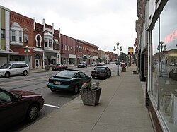
 Water Street runs concurrently with State Routes 105 and 163 in downtown Oak Harbor | |
 Location of Oak Harbor, Ohio | |
 Location of Oak Harbor in Ottawa County | |
| Coordinates: 41°30′36″N 83°08′18″W / 41.51000°N 83.13833°W | |
| Country | United States |
| State | Ohio |
| County | Ottawa |
| Government | |
| • Type | Mayor/Administrator-Council Government |
| Area | |
• Total | 1.71 sq mi (4.42 km2) |
| • Land | 1.55 sq mi (4.03 km2) |
| • Water | 0.15 sq mi (0.40 km2) |
| Elevation | 591 ft (180 m) |
| Population (2020) | |
• Total | 2,821 |
| • Density | 1,815.32/sq mi (700.69/km2) |
| Time zone | UTC-5 (Eastern (EST)) |
| • Summer (DST) | UTC-4 (EDT) |
| ZIP code | 43449 |
| Area code | 419 |
| FIPS code | 39-57582[3] |
| GNIS feature ID | 2399536[2] |
| Website | http://www.oakharbor.oh.us/ |
Oak Harbor is a village in Ottawa County, Ohio, United States. Oak Harbor is 30 miles east of Downtown Toledo. The population was 2,821 at the 2020 census. It lies a short distance southwest of the Davis-Besse Nuclear Power Station, one of two nuclear power plants in Ohio.
- ^ "ArcGIS REST Services Directory". United States Census Bureau. Retrieved September 20, 2022.
- ^ a b U.S. Geological Survey Geographic Names Information System: Oak Harbor, Ohio
- ^ "U.S. Census website". United States Census Bureau. Retrieved January 31, 2008.