Oak Hills, Oregon | |
|---|---|
Census-designated place (CDP) | |
 Entrance to the development | |
 Location of Oak Hills, Oregon | |
| Coordinates: 45°32′25″N 122°50′29″W / 45.54028°N 122.84139°W | |
| Country | United States |
| State | Oregon |
| County | Washington |
| Established | 1965 |
| Area | |
• Total | 1.56 sq mi (4.03 km2) |
| • Land | 1.56 sq mi (4.03 km2) |
| • Water | 0.00 sq mi (0.00 km2) |
| Elevation | 249 ft (76 m) |
| Population | |
• Total | 11,903 |
| • Density | 7,644.83/sq mi (2,950.99/km2) |
| Time zone | UTC-8 (Pacific (PST)) |
| • Summer (DST) | UTC-7 (PDT) |
| ZIP code | 97006 |
| Area code(s) | 503 and 971 |
| FIPS code | 41-53988[4] |
| GNIS feature ID | 2408963[2] |
Oak Hills Historic District | |
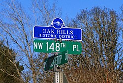
 District sign | |
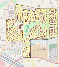
 The Oak Hills Historic District boundaries (black line), and historic contributing resources in the district (brown). | |
| Location | Roughly bounded by NW West Union & Cornell Roads, NW 143rd Ave., and Bethany Blvd. Washington County, Oregon |
| Area | 240 acres (97 ha)[6] |
| Architect | Multiple |
| NRHP reference No. | 13000482[5] |
| Added to NRHP | July 10, 2013[5][6] |
Oak Hills is a census-designated place (CDP) and neighborhood in Washington County, Oregon, United States. The CDP population was 11,903 at the 2020 census. It is on unincorporated land north of Beaverton, west of Cedar Mill, and south/southeast of Bethany. The CDP is roughly bounded by the Sunset Highway on the south, West Union Road on the north, Northwest 174th Avenue on the west, and Northwest 143rd Avenue on the east. The U.S. Postal Service has assigned Beaverton addresses to the area. Fire protection and EMS services are provided through Tualatin Valley Fire and Rescue.[7]

The Oak Hills neighborhood is substantially smaller than the CDP, and is contained within the area bounded by Cornell Road on the south, West Union Road on the north, Bethany Boulevard on the west, and Northwest 143rd Avenue on the east. It was a planned community and was built in the 1960s.[8] The first ten homes were completed in May 1965,[9] the first of about 650 planned, in an area of approximately 250 acres (100 ha).[10] Oak Hills today includes around 650 residences,[8] of which 627 are single-family homes.[6] It is managed by the Oak Hills Homeowners Association (OHHA).
The neighborhood was listed on the National Register of Historic Places in 2013, as the Oak Hills Historic District.[5][6]
- ^ "ArcGIS REST Services Directory". United States Census Bureau. Retrieved October 12, 2022.
- ^ a b U.S. Geological Survey Geographic Names Information System: Oak Hills, Oregon
- ^ Cite error: The named reference
USCensusDecennial2020CenPopScriptOnlywas invoked but never defined (see the help page). - ^ "U.S. Census website". United States Census Bureau. Retrieved January 31, 2008.
- ^ a b c "Weekly List of Actions Taken on Properties [for National Register of Historic Places]: 7/08/13 through 7/12/13". National Park Service. July 19, 2013. Retrieved July 24, 2013.
- ^ a b c d Friedman, Nicole (July 19, 2013). "Oak Hills added to National Register of Historic Places". The Oregonian. Retrieved July 24, 2013.
- ^ "About TVF&R". Tualatin Valley Fire & Rescue. Retrieved March 13, 2014.
- ^ a b Smith, Emily E. (April 2, 2011). "Oak Hills residents take pride in Rummer-designed homes scattered through the midcentury neighborhood". The Oregonian. p. E1. Retrieved April 11, 2011.
- ^ "New Homes On Display" (May 16, 1965). The Sunday Oregonian, p. 37.
- ^ "Oak Hills Begins Building Of Recreation Complex" (August 8, 1965). The Sunday Oregonian, Section 3, p. 9.