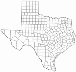
Oakhurst, Texas | |
|---|---|
 | |
 Location of Oakhurst, Texas | |
| Coordinates: 30°44′26″N 95°18′38″W / 30.74056°N 95.31056°W | |
| Country | United States |
| State | Texas |
| County | San Jacinto |
| Area | |
• Total | 1.6 sq mi (4.1 km2) |
| • Land | 1.6 sq mi (4.1 km2) |
| • Water | 0.0 sq mi (0.0 km2) |
| Elevation | 390 ft (119 m) |
| Population (2010) | |
• Total | 233 |
| • Density | 150/sq mi (57/km2) |
| Time zone | UTC-6 (Central (CST)) |
| • Summer (DST) | UTC-5 (CDT) |
| ZIP code | 77359 |
| Area code | 936 |
| FIPS code | 48-52992[1] |
| GNIS feature ID | 1382413[2] |
Oakhurst is a census-designated place and unincorporated community in San Jacinto County, Texas, United States. The population was 233 at the 2010 census. Prior to the 2010 census Oakhurst and Cape Royale CDPs were part of Oakhurst city, which has been disincorporated.[3]
- ^ "U.S. Census website". United States Census Bureau. Retrieved January 31, 2008.
- ^ "US Board on Geographic Names". United States Geological Survey. October 25, 2007. Retrieved January 31, 2008.
- ^ "Population and Housing Unit Counts, 2010 Census of Population and Housing" (PDF). Texas: 2010.