Oakville, Missouri | |
|---|---|
 Bee Tree County Park, Oakville, Missouri | |
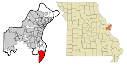
 Location of Oakville, Missouri | |
| Coordinates: 38°26′52″N 90°19′12″W / 38.44778°N 90.32000°W | |
| Country | United States |
| State | Missouri |
| County | St. Louis |
| Area | |
| • Total | 17.67 sq mi (45.77 km2) |
| • Land | 15.88 sq mi (41.12 km2) |
| • Water | 1.79 sq mi (4.65 km2) |
| Elevation | 564 ft (172 m) |
| Population (2020) | |
| • Total | 36,301 |
| • Density | 2,286.25/sq mi (882.74/km2) |
| Time zone | UTC-6 (Central (CST)) |
| • Summer (DST) | UTC-5 (CDT) |
| US | 63129 |
| Area code | 314 |
| FIPS code | 29-53876[3] |
| GNIS feature ID | 2393166[2] |
| Website | None |
Oakville is an unincorporated community and census-designated place (CDP) in south St. Louis County, Missouri, United States. The population was 36,301 at the 2020 census. Oakville is 18 miles south of the city of St. Louis and borders the Mississippi and Meramec rivers; the area is part of "South County" (south St. Louis County).
- ^ "ArcGIS REST Services Directory". United States Census Bureau. Retrieved August 28, 2022.
- ^ a b U.S. Geological Survey Geographic Names Information System: Oakville, Missouri
- ^ "U.S. Census website". United States Census Bureau. Retrieved January 31, 2008.