| Ochlockonee River | |
|---|---|
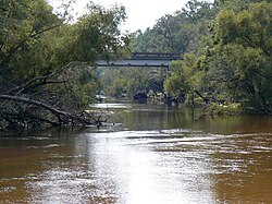
 Ochlockonee River at the Old Bainbridge Road Bridge | |
 Ochlockonee River watershed | |
| Location | |
| Country | United States |
| State | Georgia, Florida |
| District | NWFWMD |
| Physical characteristics | |
| Source | |
| • location | Gordy, Georgia |
| • coordinates | 31°29′06″N 83°52′49″W / 31.48500°N 83.88028°W |
| Mouth | Ochlockonee Bay |
• location | Surf, Florida |
• coordinates | 29°58′36″N 84°26′15″W / 29.97667°N 84.43750°W |
| Length | 206 mi (332 km) |
| Basin size | 2,450 sq mi (6,300 km2) |
| Discharge | |
| • location | Bloxham |
| • average | 1,796 cu ft/s (50.9 m3/s) |
| Basin features | |
| Tributaries | |
| • left | Sopchoppy River |
| • right | Little River, Telogia Creek, Crooked River |
The Ochlockonee River ( /oʊˈklɒknɪ/ o-KLOK-nee) is a fast running river, except where it has been dammed to form Lake Talquin in Florida, originating in Georgia and flowing for 206 miles (332 km)[1] before terminating in Florida.
- ^ Fernald, Edward A.; Patton, Donald J., eds. (1984). Water Resources Atlas of Florida. Florida State University Institute of Science and Public Affairs. ISBN 978-0-9606708-1-9.