| Ocmulgee River | |
|---|---|
 Ocmulgee River in Monroe County Recreational Park | |
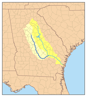
 Map of the Ocmulgee River watershed highlighted; river is dark blue | |
| Location | |
| Country | United States |
| State | Georgia |
| Physical characteristics | |
| Source | Confluence of South, Yellow, and Alcovy rivers |
| • location | Lloyd Shoals Dam |
| • coordinates | 33°19′15″N 83°50′39″W / 33.32083°N 83.84417°W |
| Mouth | Altamaha River |
• location | Hazlehurst |
| Length | 255 mi (410 km) |
| Basin features | |
| Tributaries | |
| • left | South River |
| • right | Yellow River, Alcovy River |
The Ocmulgee River (/ɒkˈmʌlɡiː/) is a western tributary of the Altamaha River, approximately 255 mi (410 km) long, in the U.S. state of Georgia. It is the westernmost major tributary of the Altamaha.[1] It was formerly known by its Hitchiti name of Ocheese Creek, from which the Creek (Muscogee) people derived their name.
The Ocmulgee River and its tributaries provide drainage for some 6,180 square miles in parts of 33 Georgia counties, a large section of the Piedmont and coastal plain of central Georgia.[1]
The Ocmulgee River basin has three river subbasins designated by the U.S. Geological Survey: the Upper Ocmulgee River subbasin (hydrologic unit code 03070103); the Lower Ocmulgee River Subbasin (03070104); and the Little Ocmulgee River Subbasin (03070105).[2]
The name of the river may have come from a Hitchiti words oki ("water") plus molki ("bubbling" or "boiling"),[3] possibly meaning "where the water boils up."[1]

- ^ a b c Ocmulgee River, New Georgia Encyclopedia (August 9, 2004).
- ^ Ocmulgee River Basin Plan, Section 2: River Basin Characteristics, Georgia Department of Natural Resources, Environmental Protection Division.
- ^ Bright, William (2004). Native American placenames of the United States. University of Oklahoma Press. p. 347. ISBN 978-0-8061-3598-4. Retrieved 16 September 2011.