Ocozocoautla de Espinosa | |
|---|---|
 | |
| Coordinates: 16°45′N 93°22′W / 16.750°N 93.367°W | |
| Country | |
| State | Chiapas |
| Municipal seat | Ocozocoautla de Espinosa |
| Government | |
| • Municipal president | Ramiro Chambé |
| Area | |
• Total | 2,084 km2 (805 sq mi) |
| • City | 9.39 km2 (3.63 sq mi) |
| Population (2020 census)[1] | |
• Total | 97,397 |
| • Density | 47/km2 (120/sq mi) |
| • City | 43,247 |
| • City density | 4,600/km2 (12,000/sq mi) |
| Time zone | UTC-6 (CST) |
| • Summer (DST) | UTC-5 (CDT) |
| Website | (in Spanish) |
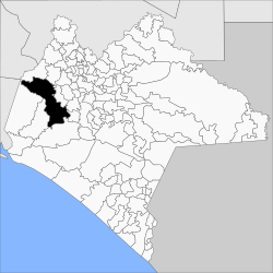
Ocozocoautla de Espinosa, colloquially Coita, is a town and municipality in the Mexican state of Chiapas. It is located in the western part of the state, 24 km west of Tuxtla Gutierrez covering parts of the Depresión Central (Central Depression) and the Montañas del Norte (Northern Mountains). It is bordered to the north by Tecpatán, to the east by Berriozábal, Tuxtla Gutiérrez and Suchiapa, to the south by Villaflores and to the west by Jiquipilas and Cintalapa. The name comes from the Nahua language and means ‘forest of ocozote trees’. ‘De Espinosa’ was added in 1928 to honor Raymundo Enríquez Espinosa who was the first governor of the state of Chiapas. Ocozocoautla gained city status in 1926. The climate is warm and humid and the vegetation is mostly high and medium rainforest.
- ^ Citypopulation.de Population of Ocozocoautla de Espinosa municipality with localities
