| Ocqueoc River | |
|---|---|
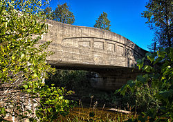
 River Road over the Ocqueoc River. | |
 | |
| Location | |
| Country | United States |
| Physical characteristics | |
| Source | |
| • location | Bismarck Township, Presque Isle County, Michigan |
| Mouth | |
• location | Lake Huron at Ocqueoc Township, Presque Isle County, Michigan |
• elevation | 584 feet (178 m)[2] |
| Length | 34 miles (55 km)[1] |
| Basin size | 94,394 acres (382.00 km2)[3] |
| Basin features | |
| Tributaries | |
| • left | Silver Creek, Little Ocqueoc River, Indian Creek |
The Ocqueoc River (/ˈɑːkiːɑːk/ AH-key-ock) is a 34.2-mile-long (55.0 km)[1] blackwater river in the U.S. state of Michigan. The river is located in the northeastern Lower Peninsula, flowing into Lake Huron in Presque Isle County. The river drains a watershed of approximately 94,394 acres (382.00 km2).[3] Along the river are the Ocqueoc Falls, the largest and only named waterfall in Michigan's Lower Peninsula.[4][5]
Ocqueoc is a French adaptation of an Anishinabemowin (Ojibwe) term meaning "crooked waters".[6]
- ^ a b U.S. Geological Survey. National Hydrography Dataset high-resolution flowline data. The National Map, accessed November 21, 2011
- ^ U.S. Geological Survey Geographic Names Information System: Ocqueoc River
- ^ a b Ocqueoc River Watershed Management Plan, 2005, Ocqueoc River Watershed Commission, Accessed 22 August 2010
- ^ "Ocqueoc Falls Scenic Site". US-23 Heritage Route. Retrieved 2024-01-10.
- ^ "Michigan Recreation Search Site Details Page". www2.dnr.state.mi.us. Retrieved 2024-01-10.
- ^ Romig, Walter (1986) [1973]. Michigan Place Names. Detroit, Michigan: Wayne State University Press. ISBN 0-8143-1838-X.