Ōhaupō railway station | |||||||||||
|---|---|---|---|---|---|---|---|---|---|---|---|
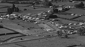
 Aerial view of Ōhaupō in 1964 – station bottom right | |||||||||||
| General information | |||||||||||
| Location | New Zealand | ||||||||||
| Coordinates | 37°55′16″S 175°18′10″E / 37.921011°S 175.30283°E | ||||||||||
| Elevation | 52 m (171 ft) | ||||||||||
| Line(s) | North Island Main Trunk | ||||||||||
| Distance | Wellington 527.16 km (327.56 mi) | ||||||||||
| History | |||||||||||
| Opened | 4 June 1878 | ||||||||||
| Closed | 13 June 1982[1] | ||||||||||
| Electrified | June 1988 | ||||||||||
| Services | |||||||||||
| |||||||||||

Ōhaupō railway station was a station located at Ōhaupō on the North Island Main Trunk in New Zealand.[2][3] It was the terminus of the line from Auckland from 1878 to 1880 and closed in 1982. Only a passing loop remains.[4]
- ^ Juliet Scoble: Names & Opening & Closing Dates of Railway Stations in New Zealand
- ^ New Zealand Railway and Tramway Atlas (First ed.). Quail Map Co. 1965. pp. 3 & 4.
- ^ Pierre, Bill (1981). North Island Main Trunk. Wellington: A.H&A.W Reed. pp. 289–290. ISBN 0589013165.
- ^ "Sandes St". Google Maps. Retrieved 8 April 2021.