 | ||||
| Route information | ||||
| Maintained by ODOT | ||||
| Length | 43.38 mi[1] (69.81 km) | |||
| Existed | 1962[2]–present | |||
| Major junctions | ||||
| South end | ||||
| North end | ||||
| Location | ||||
| Country | United States | |||
| State | Ohio | |||
| Counties | Tuscarawas, Carroll, Stark, Portage | |||
| Highway system | ||||
| ||||
| ||||
| ||||
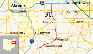
State Route 183 (SR 183) is a north/south state Highway in eastern Ohio. Its southern terminus is SR 800 in Sandy Township, approximately 0.5 miles (0.80 km) east of Sandyville and less than two miles (3.2 km) south of East Sparta. Its northern terminus is SR 14 in Edinburg Township near Interstate 76, about 10 miles (16 km) southeast of Ravenna. The current route was commissioned in 1962.
- ^ "DESTAPE". Ohio Department of Transportation. July 3, 2014. Retrieved September 1, 2014.
- ^ "Will Rt. 75 Become Known As Rt. 93?". The Logan Daily News. April 27, 1962. p. 1. Retrieved June 10, 2016 – via Newspapers.com.

