State highway in central Ohio, US
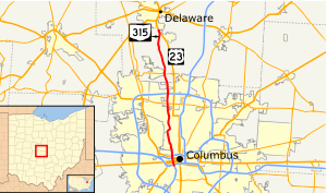
State Route 315, known locally as the Olentangy Freeway, running almost parallel to Olentangy River Road for most of its length,[3] is a north–south highway in central Ohio, in the Columbus metropolitan area. It may be seen abbreviated as SR 315, OH-315, or simply 315. Its southern terminus is at the south junction of I-70 and I-71 in Columbus, and its northern terminus is at US 23 near Delaware. It is a controlled access freeway from its southern terminus to I-270. The controlled access section carries two or three lanes in each direction, depending on the location. North of I-270, it becomes a two-lane road. It roughly follows the Olentangy River for about two-thirds of its length. The route passes through Ohio State University campus. The section between Interstate 670 and Interstate 70 is known as the West Innerbelt, and it is commonly referred to as such in traffic reports. The original name of this section was Sandusky Street.

