 | ||||
| Route information | ||||
| Maintained by ODOT | ||||
| Length | 13.08 mi[1] (21.05 km) | |||
| Existed | 1960–present | |||
| Major junctions | ||||
| West end | ||||
| East end | ||||
| Location | ||||
| Country | United States | |||
| State | Ohio | |||
| Counties | Richland, Ashland | |||
| Highway system | ||||
| ||||
| ||||

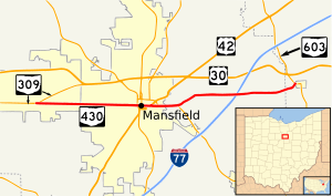
State Route 430 (SR 430, OH 430) is an east–west state highway in the northern portion of Ohio. The western terminus of State Route 430 is at an interchange with State Route 309 in Ontario. Its eastern terminus is at a T-intersection with State Route 603 just outside Mifflin.
- ^ Ohio Department of Transportation. "Technical Services Straight Line Diagrams". Retrieved 2008-03-16.
