| Ok Tedi | |
|---|---|
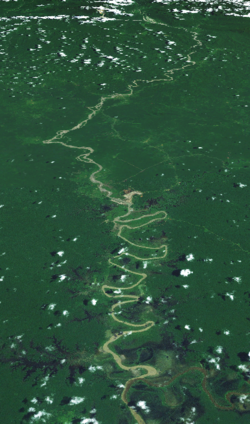
 Satellite image of the Ok Tedi River | |
 Location of the Ok Tedi | |
| Location | |
| Country | Papua New Guinea, Indonesia |
| Region | Western Province |
| Physical characteristics | |
| Source | |
| • location | Star Mountains, Papua New Guinea |
| • coordinates | 5°5′24″S 141°13′5″E / 5.09000°S 141.21806°E |
| • elevation | 1,619 m (5,312 ft) |
| Mouth | |
• location | Fly, Papua New Guinea |
• coordinates | 6°10′5″S 141°7′8.5″E / 6.16806°S 141.119028°E |
• elevation | 22 m (72 ft) |
| Length | 207 km (129 mi) |
| Basin size | 5,360 km2 (2,070 sq mi) |
| Basin features | |
| Tributaries | |
| • left | Ok Menga, Ok Ma |
The Ok Tedi is a river in New Guinea. The Ok Tedi Mine is located near the headwaters of the river, which is sourced in the Star Mountains. It is the second largest tributary of the Fly River. Nearly the entirety of the river runs through the North Fly District of the Western Province of Papua New Guinea, but the river crosses the international boundary with Indonesia for less than one kilometre. The largest settlement of the Western Province, Tabubil is located near its banks.