This article needs additional citations for verification. (December 2012) |
Okanagan
Okanagan Valley | |
|---|---|
 Vineyards of the central Okanagan Valley | |
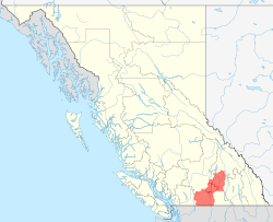
 Location of the Okanagan in British Columbia | |
| Coordinates: 49°44′52″N 119°43′02″W / 49.74778°N 119.71722°W | |
| Country | Canada |
| Province | British Columbia |
| Principal cities | |
| Area | |
| • 3 Districts | 20,817 km2 (8,037 sq mi) |
| Population (2023) | 439,852[2] |
| • Density | 21.1/km2 (55/sq mi) |
| Time zone | UTC−08:00 (PST) |
| • Summer (DST) | UTC−07:00 (PDT) |
| Postal code prefixes | |
| Area codes | 236, 672, 778, 250 |
The Okanagan (/ˌoʊkəˈnɑːɡən/ OH-kə-NAH-gən),[3] also called the Okanagan Valley and sometimes the Okanagan Country, is a region in the Canadian province of British Columbia defined by the basin of Okanagan Lake and the Canadian portion of the Okanagan River. It is part of the Okanagan Country, extending into the United States as Okanogan County in north-central Washington. According to the 2016 Canadian census, the region's population is 362,258. The largest populated cities are Kelowna, Penticton, Vernon, and West Kelowna.
The region is known for its sunny climate, dry landscapes and lakeshore communities and particular lifestyle.[4] The economy is retirement and commercial-recreation based, with outdoor activities such as boating and watersports, skiing and hiking. Agriculture has been focused primarily on fruit orchards, with a recent shift in focus to vineyards and wine.
The region stretches northwards via the Spallumcheen Valley to Sicamous in the Shuswap Country, and reaches south of the Canada–United States border, where it continues as Okanogan County. The Okanagan as a region is sometimes described as including the Boundary, Similkameen, and Shuswap regions, though this is because of proximity and historic and commercial ties with those areas.
- ^ "2016 Census Profile, 2016 Census - Okanagan Health Service Delivery Area [Health region, December 2017]". Retrieved 2024-10-25.
- ^ Population Estimates – Province of British Columbia
- ^ OHK-ə-NAH-gən
- ^ The Main Report of the Consultative Board. Canada – British Columbia Okanagan Basin Agreement (PDF) (Report). Victoria, British Columbia: British Columbia Water Resources Service. March 1974. p. 11. Retrieved 2015-10-25.
the region is both scenically attractive and climatically desirable, and has consequently experienced a rapidly expanding resident and tourist population growth