| UNESCO World Heritage Site | |
|---|---|
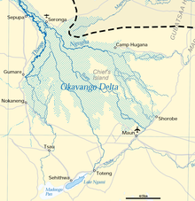
 Map of the delta with basin boundary as dashed line | |
| Location | Botswana |
| Criteria | Natural: vii, ix, x |
| Reference | 1432 |
| Inscription | 2014 (38th Session) |
| Area | 2,023,590 ha |
| Buffer zone | 2,286,630 ha |
| Coordinates | 19°24′S 22°54′E / 19.400°S 22.900°E |
| Official name | Okavango Delta System |
| Designated | 12 September 1996 |
| Reference no. | 879[1] |


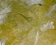
The Okavango Delta[2] (or Okavango Grassland; formerly spelled "Okovango" or "Okovanggo") in Botswana is a vast inland delta formed where the Okavango River reaches a tectonic trough at an altitude of 930–1,000 m[3] in the central part of the endorheic basin of the Kalahari.
It is a UNESCO World Heritage Site as one of the few interior delta systems that do not flow into a sea or ocean, with a wetland system that is largely intact.[4] All the water reaching the delta is ultimately evaporated and transpired. Each year, about 11 cubic kilometres (2.6 cu mi) of water spreads over the 6,000–15,000 km2 (2,300–5,800 sq mi) area. Some flood waters drain into Lake Ngami.[5] The area was once part of Lake Makgadikgadi, an ancient lake that had mostly dried up by the early Holocene.[6]
The Moremi Game Reserve is on the eastern side of the delta. The delta was named one of the Seven Natural Wonders of Africa, which were officially declared on 11 February 2013 in Arusha, Tanzania.[7] On 22 June 2014, the Okavango Delta became the 1000th site to be officially inscribed on the UNESCO World Heritage List.[8][4]
- ^ "Okavango Delta System". Ramsar Sites Information Service. Archived from the original on 26 July 2018. Retrieved 25 April 2018.
- ^ Ross, Karen (1987). Okavango, jewel of the Kalahari. London: BBC Books. ISBN 0-563-20545-8. OCLC 17978845.
- ^ "Ramsar Information Sheet" (PDF). 20 November 1996. Archived (PDF) from the original on 31 August 2021. Retrieved 17 January 2021.
The total drop in altitude between Mohembo and Maun, a distance of440 km, is only 62 metres, giving a gradient of approximately 1:7,000 only
- ^ a b Centre, UNESCO World Heritage. "Twenty six new properties added to World Heritage List at Doha meeting". whc.unesco.org. Archived from the original on 26 July 2018. Retrieved 4 April 2018.
- ^ Cite error: The named reference
Keenwas invoked but never defined (see the help page). - ^ Cite error: The named reference
McCarthy1was invoked but never defined (see the help page). - ^ "Seven Natural Wonders of Africa – Seven Natural Wonders". sevennaturalwonders.org. Archived from the original on 21 December 2015. Retrieved 22 March 2013.
- ^ Centre, UNESCO World Heritage. "World Heritage List reaches 1000 sites with inscription of Okavango Delta in Botswana". whc.unesco.org. Archived from the original on 26 July 2018. Retrieved 4 April 2018.
