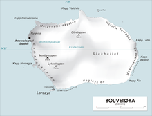
Olavtoppen,[1][2] occasionally anglicised as Olav Peak, is the highest point of Bouvet Island, a volcanic island and dependency of Norway, and the remotest island on Earth. Olavtoppen is located north of the center of the island, immediately south of Kapp Valdivia, and rises 780 meters (2,560 ft) above sea level.[1] It was first ascended on 21 February 2012 by Aaron Halstead, Bruno Rodi and Jason Rodi[3] Olavtoppen is ranked 36th by topographic isolation.
- ^ a b Barr, Susan (1987). Norway's Polar Territories. Oslo: Aschehoug. p. 59. ISBN 82-03-15689-4.
- ^ P. E. Baker (1967). "Historical and Geological Notes on Bouvetøya" (PDF). British Antarctic Survey Bulletin (13): 71–84. Archived from the original (PDF) on 16 March 2012. Retrieved 8 May 2012.
- Rubin, Jeff (2005). Antarctica. Lonely Planet. p. 155. ISBN 1-74059-094-5. - ^ Jason Rodi: Making History – Summiting of the most remote land on Earth Archived 2013-03-13 at the Wayback Machine