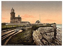
 Old Hunstanton Lighthouse | |
 | |
| Location | St Edmund’s Point Norfolk England |
|---|---|
| OS grid | TF6763042048 |
| Coordinates | 52°56′59″N 0°29′38″E / 52.949645°N 0.493760°E |
| Tower | |
| Constructed | c. 1665 (first) 1778 (second) |
| Construction | masonry tower |
| Height | 19 metres (62 ft) |
| Shape | cylindrical tower with balcony attached to 2-storey keeper's house |
| Markings | white tower |
| Operator | The Old Lighthouse[1] |
| Heritage | Grade II listed building |
| Light | |
| First lit | 1840 (current) |
| Deactivated | 1922 |
Listed Building – Grade II | |
| Official name | The Lighthouse |
| Designated | 20 September 1984 |
| Reference no. | 1171495[2] |
Old Hunstanton Lighthouse is a former lighthouse located in Old Hunstanton in the English county of Norfolk,[3][4] generally called Hunstanton Lighthouse (or, less formally, 'Hunston Lighthouse') during its operational life. It was built at the highest point available on this part of the coast, on top of Hunstanton Cliffs,[5] and served to help guide vessels into the safe water of Lynn Deeps.[6] Although the present lighthouse was built in 1840, there had been a lighthouse on the site since the 17th century (prior to which a light to aid navigation may have been displayed from St Edmund's Chapel, the ruins of which stand nearby).[7] Prior to the establishment of the Lynn Well light vessel in 1828, Hunstanton Lighthouse provided the only visible guide to ships seeking to enter The Wash at night.[8]
- ^ Rowlett, Russ. "Lighthouses of Eastern England". The Lighthouse Directory. University of North Carolina at Chapel Hill. Retrieved 28 April 2016.
- ^ Listed Building schedule
- ^ "Hunstanton Heritage Week: Hunstanton Lighthouse". Hunstanton Town and Around. 19 September 2019. Retrieved 1 February 2020.
- ^ Ordnance Survey (2002). OS Explorer Map 250 - Norfolk Coast West. ISBN 0-319-21886-4.
- ^ Cite error: The named reference
RC1861was invoked but never defined (see the help page). - ^ Cite error: The named reference
Norrie1846was invoked but never defined (see the help page). - ^ Naish, John (1985). Seamarks: Their History and Development. London: Stanford Maritime. p. 83.
- ^ "Light Vessels". The Nautical Magazine and Naval Chronicle (9): 642. September 1839.