This article includes a list of general references, but it lacks sufficient corresponding inline citations. (July 2011) |
Old Montreal | |
|---|---|
| Vieux-Montréal | |
 View of Old Montreal from the Old Port of Montreal | |
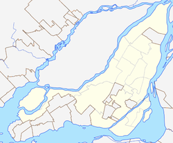
Location of Old Montreal in Montreal | |
| Coordinates: 45°30′18″N 73°33′18″W / 45.50500°N 73.55500°W | |
| Country | Canada |
| Province | Quebec |
| City | Montreal |
| Borough | Ville-Marie |
| Area | |
| • Land | 0.71 km2 (0.27 sq mi) |
| Population | |
| • Total | 4,531 |
| • Density | 6,381.7/km2 (16,529/sq mi) |
| • Change (2006-11) | |
| • Dwellings | 3,312 |
| Postal Code | |
| Area code(s) | 514, 438 |
| Official name | Site patrimonial de Montréal |
| Type | Site patrimonial déclaré |
| Designated | 1964-01-08 |
| Reference no. | 93528 |
Old Montreal (French: Vieux-Montréal) is a historic neighbourhood within the municipality of Montreal in the province of Quebec, Canada. Home to the Old Port of Montreal, the neighbourhood is bordered on the west by McGill Street, on the north by Ruelle des Fortifications, on the east by rue Saint-André, and on the south by the Saint Lawrence River. Following recent amendments, the neighbourhood has expanded to include the Rue des Soeurs Grises in the west, Saint Antoine Street in the north, and Saint Hubert Street in the east.
Founded by French settlers in 1642 as Fort Ville-Marie, Old Montreal is home to many structures dating back to the era of New France.[2] The 17th century settlement lends its name to the borough in which the neighbourhood lies, Ville-Marie. In 1964, much of Old Montreal was declared a historic district by the Ministère des Affaires culturelles du Québec.[2]
- ^ a b "Census Profile: Census Tract: 4620055.01". Canada 2011 Census. Statistics Canada. February 8, 2012. Retrieved April 1, 2012.
- ^ a b "Old Montréal / Centuries of History - Ville-Marie". www.vieux.montreal.qc.ca. Retrieved October 1, 2018.
