Old Road | |
|---|---|
Town | |
| Town of Old Road | |
 Old Road in 2023 | |
 | |
| Coordinates: 17°01′N 61°50′W / 17.017°N 61.833°W | |
| Country | Antigua and Barbuda |
| Island | Antigua |
| Parish | Saint Mary |
| Major division | Old Road |
| Founded | 1700s[1] |
| Area | |
| • Total | 10.325 km2 (3.987 sq mi) |
| Population (2011) | |
| • Total | 1,251 |
| • Density | 121.16/km2 (313.8/sq mi) |
| Time zone | UTC-4 (AST) |
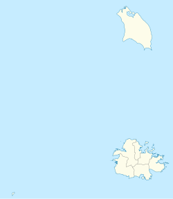
Old Road, officially known as the Town of Old Road, is a town located on a roadstead in the parish of Saint Mary, Antigua and Barbuda.[2] It is overlooked by Boggy Peak, which lies to its northwest. Old Road was founded in the 1700s,[1] and in the 1850s was still a tiny settlement of 96, smaller than its neighbour to the west, Urlings.[3] Old Road has since grown to a population of 1,251 in 2011, and is now the tenth largest settlement in the country. Old Road is smaller than Willikies, but is larger than Montclear, Skyline, and Potters Village. Old Road is separated from the rest of Antigua by the Shekerley Mountains. The village is located on Andy Roberts Drive which to the east, merges onto Fig Tree Drive leading to John Hughes, and to the west, continues through Urlings, Crabs Hill, and Johnsons Point before merging onto Valley Road in Ffryes village.
Old Road contains a sports complex,[4] Morris Bay beach, Carlisle Bay beach, and the St. Mary's parish church. Old Road also has a primary school, and in sports, is home to the Old Road F.C. and a cricket club.[5]
- ^ a b "Antigua and Barbuda: National Urban Profile" (PDF).
- ^ "Find Old Road, Antigua, Antigua and Barbuda Hotels- Downtown Hotels in Old Road- Hotel Search by Hotel & Travel Index: Travel Weekly". www.travelweekly.com. Retrieved 2023-09-30.
- ^ Commons, Great Britain Parliament House of (1858). Accounts and Papers of the House of Commons. Ordered to be printed.
- ^ "Spring Hill Riding Club". Archived from the original (GML) on 2023-11-02.
- ^ "Old Road". Cricket268. 2023-05-21. Retrieved 2023-09-30.
