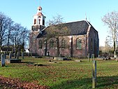
Oldambt | |
|---|---|
|
| |
 Location of Oldambt in Groningen in the Netherlands | |
| Coordinates: 53°9′N 7°2′E / 53.150°N 7.033°E | |
| Country | Netherlands |
| Province | Groningen |
| Established | 1 January 2010[1] |
| Government | |
| • Body | Municipal council |
| • Mayor | Cora-Yfke Sikkema (GL) |
| Area | |
| • Total | 295.96 km2 (114.27 sq mi) |
| • Land | 226.66 km2 (87.51 sq mi) |
| • Water | 69.30 km2 (26.76 sq mi) |
| Elevation | 2 m (7 ft) |
| Population (January 2021)[5] | |
| • Total | 38,277 |
| • Density | 169/km2 (440/sq mi) |
| Time zone | UTC+1 (CET) |
| • Summer (DST) | UTC+2 (CEST) |
| Postcode | Parts of 9600 and 9900 ranges |
| Area code | 0596–0598 |
| Website | gemeente-oldambt.nl |
Oldambt (Dutch pronunciation: [ɔlˈdɑm(p)t])[6] is a municipality with a population of 38,277 in the province of Groningen in the Netherlands. It was established in 2010 by merging the municipalities of Reiderland, Scheemda, and Winschoten. It contains the city of Winschoten and these villages:
- ^ "Gemeentelijke indeling op 1 januari 2010" [Municipal divisions on 1 January 2010]. cbs.nl (in Dutch). CBS. Retrieved 31 January 2014.
- ^ "Samenstelling college van B&W" [Members of the board of mayor and aldermen] (in Dutch). Gemeente Oldambt. Archived from the original on 21 February 2014. Retrieved 3 February 2014.
- ^ "Kerncijfers wijken en buurten 2020" [Key figures for neighbourhoods 2020]. StatLine (in Dutch). CBS. 24 July 2020. Retrieved 19 September 2020.
- ^ "Postcodetool for 9671CD". Actueel Hoogtebestand Nederland (in Dutch). Het Waterschapshuis. Retrieved 3 February 2014.
- ^ "Bevolkingsontwikkeling; regio per maand" [Population growth; regions per month]. CBS Statline (in Dutch). CBS. 1 January 2021. Retrieved 2 January 2022.
- ^ "Heringedeeld afl 3 'Oldambt'". YouTube. Retrieved 3 April 2023.


