Oldmans Township, New Jersey | |
|---|---|
 Farm house at Sweet Haven Farms | |
 Oldmans Township highlighted in Salem County. Inset map: Salem County highlighted in the State of New Jersey. | |
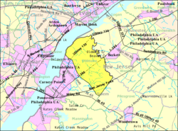
 Census Bureau map of Oldmans Township, New Jersey | |
Location in Salem County Location in New Jersey | |
| Coordinates: 39°45′24″N 75°25′49″W / 39.75667°N 75.43028°W[1][2] | |
| Country | |
| State | |
| County | |
| Incorporated | February 7, 1881 |
| Government | |
| • Type | Township |
| • Body | Township Committee |
| • Mayor | Dean W. Sparks (R, term ends December 31, 2023)[3][4] |
| • Municipal clerk | Melinda Taylor[5] |
| Area | |
| • Total | 20.69 sq mi (53.58 km2) |
| • Land | 19.51 sq mi (50.53 km2) |
| • Water | 1.18 sq mi (3.05 km2) 5.70% |
| • Rank | 137th of 565 in state 9th of 15 in county[1] |
| Elevation | 30 ft (9 m) |
| Population | |
| • Total | 1,910 |
| • Estimate (2023)[9] | 1,928 |
| • Rank | 490th of 565 in state 11th of 15 in county[10] |
| • Density | 97.9/sq mi (37.8/km2) |
| • Rank | 543rd of 565 in state 11th of 15 in county[10] |
| Time zone | UTC−05:00 (Eastern (EST)) |
| • Summer (DST) | UTC−04:00 (Eastern (EDT)) |
| ZIP Code | |
| Area code | 856[13] |
| FIPS code | 3403354810[1][14][15] |
| GNIS feature ID | 0882136[1][16] |
| Website | www |
Oldmans Township is a township in Salem County, in the U.S. state of New Jersey. As of the 2020 United States census, the township's population was 1,910,[8] an increase of 137 (+7.7%) from the 2010 census count of 1,773,[17][18] which in turn reflected a decline of 25 (−1.4%) from the 1,798 counted in the 2000 census.[19]
Oldmans Township was incorporated on February 7, 1881, from portions of Upper Penns Neck Township (now Carneys Point Township).[20] The township's name is a corruption of "Alderman's".[21]
It is a dry town, where alcohol cannot be sold legally, though alcohol is available at the winery in the township.[22][23]
- ^ a b c d e 2019 Census Gazetteer Files: New Jersey Places, United States Census Bureau. Accessed July 1, 2020.
- ^ US Gazetteer files: 2010, 2000, and 1990, United States Census Bureau. Accessed September 4, 2014.
- ^ Cite error: The named reference
Committeewas invoked but never defined (see the help page). - ^ 2023 New Jersey Mayors Directory, New Jersey Department of Community Affairs, updated February 8, 2023. Accessed February 10, 2023.
- ^ Township Clerk, Oldmans Township. Accessed August 23, 2022.
- ^ Cite error: The named reference
DataBookwas invoked but never defined (see the help page). - ^ U.S. Geological Survey Geographic Names Information System: Township of Oldmans, Geographic Names Information System. Accessed March 8, 2013.
- ^ a b Cite error: The named reference
LWD2020was invoked but never defined (see the help page). - ^ Cite error: The named reference
PopEstwas invoked but never defined (see the help page). - ^ a b Population Density by County and Municipality: New Jersey, 2020 and 2021, New Jersey Department of Labor and Workforce Development. Accessed March 1, 2023.
- ^ Look Up a ZIP Code for Pedricktown, NJ, United States Postal Service. Accessed January 17, 2013.
- ^ Look Up a ZIP Code for Auburn, NJ, United States Postal Service. Accessed January 17, 2013.
- ^ Area Code Lookup - NPA NXX for Pedricktown, NJ, Area-Codes.com. Accessed October 30, 2013.
- ^ U.S. Census website, United States Census Bureau. Accessed September 4, 2014.
- ^ Geographic Codes Lookup for New Jersey, Missouri Census Data Center. Accessed April 1, 2022.
- ^ US Board on Geographic Names, United States Geological Survey. Accessed September 4, 2014.
- ^ Cite error: The named reference
Census2010was invoked but never defined (see the help page). - ^ Cite error: The named reference
LWD2010was invoked but never defined (see the help page). - ^ Table 7. Population for the Counties and Municipalities in New Jersey: 1990, 2000 and 2010, New Jersey Department of Labor and Workforce Development, February 2011. Accessed May 1, 2023.
- ^ Snyder, John P. The Story of New Jersey's Civil Boundaries: 1606–1968, Bureau of Geology and Topography; Trenton, New Jersey; 1969. p. 216. Accessed May 30, 2024.
- ^ Hutchinson, Viola L. The Origin of New Jersey Place Names, New Jersey Public Library Commission, May 1945. Accessed September 15, 2015.
- ^ New Jersey Division of Alcoholic Beverage Control. New Jersey ABC list of dry towns (May 1, 2013)
- ^ Giordano, Rita. "More towns catching liquor-license buzz; Moorestown considers ending its dry spell", The Philadelphia Inquirer, June 24, 2007. Accessed February 16, 2014.


