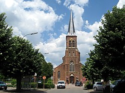
Olen | |
|---|---|
 | |
| Coordinates: 51°09′N 04°51′E / 51.150°N 4.850°E | |
| Country | |
| Community | Flemish Community |
| Region | Flemish Region |
| Province | Antwerp |
| Arrondissement | Turnhout |
| Government | |
| • Mayor | Seppe Bouquillon (CD&V) |
| • Governing party/ies | CD&V, sp.a, Groen |
| Area | |
| • Total | 23.12 km2 (8.93 sq mi) |
| Population (2020-01-01)[1] | |
| • Total | 12,560 |
| • Density | 540/km2 (1,400/sq mi) |
| Postal codes | 2250 |
| NIS code | 13029 |
| Area codes | 014, 04 |
| Website | www.olen.be |
Olen (Dutch pronunciation: [ˈoːlə(n)]) is a municipality located in the Belgian province of Antwerp. The municipality comprises three towns, situated on a south–north axis:
- South of the motorway E313 and the Albert Canal is Olen proper, also called Olen-Centrum (Saint-Martins parish).
- Between the Albert Canal and Olen-station (railroad from Antwerp to Neerpelt and Hasselt) is the town of Boekel, also called Onze-Lieve-Vrouw-Olen (parish) or Achter-Olen (Behind-Olen).
- North of the railroad is the town of St.-Jozef-Olen (parish), also called Olen-Fabriek (Olen-Factory, a refinery along the old canal Herentals-Bocholt that was at its origin).
In 2021, Olen had a total population of 12,600.[2] The total area is 23.10 km2.
- ^ "Bevolking per gemeente op 1 januari 2020". Statbel.
- ^ "Bevolking per statistische sector - Sector 13029". Statistics Belgium. Retrieved 10 May 2022.


