| Olenti Өлеңті | |
|---|---|
 Final stretch of the Olenti and its mouth in the Auliekol western lakeshore Sentinel-2 image | |
| Location | |
| Countries | Kazakhstan |
| Physical characteristics | |
| Source | Yereymentau Kazakh Uplands |
| • coordinates | 50°54′52″N 72°57′05″E / 50.91444°N 72.95139°E |
| • elevation | ca 530 m (1,740 ft) |
| Mouth | Auliekol |
• coordinates | 52°11′00″N 74°46′04″E / 52.18333°N 74.76778°E |
• elevation | 126 m (413 ft) |
| Length | 273 km (170 mi) |
| Basin size | 4,320 km2 (1,670 sq mi) |
| Discharge | |
| • average | 0.6 cubic metres per second (21 cu ft/s) at its mouth |
The Olenti (Kazakh: Өлеңті; Russian: Оленти) is a river in the Akmola, Karaganda and Pavlodar regions, Kazakhstan. It is 273 kilometres (170 mi) long and has a catchment area of 4,320 square kilometres (1,670 sq mi).[1]
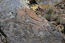
The Olenti belongs to the Irtysh basin. The name of the river originated in the Kazakh word for sedge.[1] There are petroglyphs on the right bank of the lower course of the river, 10 km (6.2 mi) south-west of Tai village, part of the Ekibastuz City Administration.[2]
 |
- ^ a b Cite error: The named reference
KEwas invoked but never defined (see the help page). - ^ Olenty neolithic drawings
