Olivehurst, California | |
|---|---|
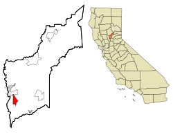
 Location in Yuba County and the state of California | |
| Coordinates: 39°05′44″N 121°33′08″W / 39.09556°N 121.55222°W | |
| Country | |
| State | |
| County | Yuba |
| Area | |
| • Total | 7.473 sq mi (19.354 km2) |
| • Land | 7.473 sq mi (19.354 km2) |
| • Water | 0 sq mi (0 km2) 0% |
| Elevation | 66 ft (20 m) |
| Population | |
| • Total | 16,595 |
| • Density | 2,200/sq mi (860/km2) |
| Time zone | UTC-8 (Pacific (PST)) |
| • Summer (DST) | UTC-7 (PDT) |
| ZIP code | 95961 |
| Area code | 530 |
| FIPS code | 06-53714 |
| GNIS feature ID | 1659301 |
Olivehurst (formerly, Denniston)[3] is a census-designated place (CDP) in Yuba County, California, United States. The population was 13,656 at the 2010 census, up from 11,061 at the 2000 census. Olivehurst is located 4 miles (6.4 km) south-southeast of Marysville.[3]
- ^ U.S. Census Archived January 25, 2012, at the Wayback Machine
- ^ "US Census Bureau". www.census.gov. Retrieved December 31, 2023.
- ^ a b Durham, David L. (1998). California's Geographic Names: A Gazetteer of Historic and Modern Names of the State. Clovis, Calif.: Word Dancer Press. p. 533. ISBN 1-884995-14-4.
