Olneyville | |
|---|---|
 | |
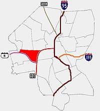
 Location of Olneyville within Providence | |
| Coordinates: 41°49′17″N 71°26′46″W / 41.821424°N 71.445977°W | |
| Country | |
| State | |
| City | Providence |
Olneyville is a neighborhood in Providence, Rhode Island bordered by Atwells Avenue to the north, U.S. Route 6 to the south and Rhode Island Route 10 to the east. The Woonasquatucket River runs through the southern portion of the neighborhood. The area is roughly triangular.
Olneyville Square is a major traffic intersection in Olneyville, defined by the intersection of Westminster Street, Broadway, Hartford Ave, Plainfield Street, and Manton Avenue.