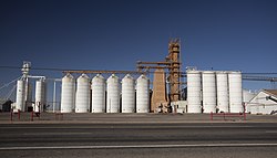
Olton, Texas | |
|---|---|
City | |
 Olton Grain Cooperative | |
| Coordinates: 34°11′00″N 102°08′05″W / 34.18333°N 102.13472°W | |
| Country | |
| State | |
| County | Lamb |
| Region | Llano Estacado |
| Established | 1906 |
| Area | |
| • Total | 1.36 sq mi (3.52 km2) |
| • Land | 1.36 sq mi (3.52 km2) |
| • Water | 0.00 sq mi (0.00 km2) |
| Elevation | 3,612 ft (1,101 m) |
| Population (2020) | |
| • Total | 1,989 |
| • Density | 1,500/sq mi (570/km2) |
| Time zone | UTC-6 (CST) |
| ZIP code | 79064 |
| Area code | 806 |
| FIPS code | 48-54012 |
Olton is a city in Lamb County, Texas, United States. The population was 1,989 at the 2020 census.[3]
- ^ "2019 U.S. Gazetteer Files". United States Census Bureau. Retrieved August 7, 2020.
- ^ "Olton". Geographic Names Information System. United States Geological Survey, United States Department of the Interior.
- ^ Cite error: The named reference
:0was invoked but never defined (see the help page).
