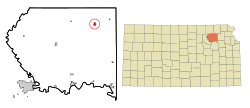
Onaga, Kansas | |
|---|---|
 Location within Pottawatomie County and Kansas | |
 | |
| Coordinates: 39°29′21″N 96°10′13″W / 39.48917°N 96.17028°W[1] | |
| Country | United States |
| State | Kansas |
| County | Pottawatomie |
| Platted | 1877 |
| Incorporated | by 1881, 1926 |
| Named for | Onago |
| Area | |
| • Total | 0.66 sq mi (1.70 km2) |
| • Land | 0.66 sq mi (1.70 km2) |
| • Water | 0.00 sq mi (0.00 km2) |
| Elevation | 1,112 ft (339 m) |
| Population | |
| • Total | 679 |
| • Density | 1,000/sq mi (400/km2) |
| Time zone | UTC-6 (CST) |
| • Summer (DST) | UTC-5 (CDT) |
| ZIP code | 66521 |
| Area code | 785 |
| FIPS code | 20-52875 |
| GNIS ID | 2396065[1] |
| Website | cityofonaga.com |
Onaga is a city in Pottawatomie County, Kansas, United States.[1] As of the 2020 census, the population of the city was 679.[3]
- ^ a b c d U.S. Geological Survey Geographic Names Information System: Onaga, Kansas
- ^ "2019 U.S. Gazetteer Files". United States Census Bureau. Retrieved July 24, 2020.
- ^ a b "Profile of Onaga, Kansas in 2020". United States Census Bureau. Archived from the original on May 26, 2022. Retrieved May 26, 2022.