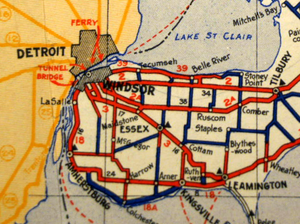
 Highway 18A (in thick blue) as it appeared in the 1938–39 Ontario Road Map | ||||
| Route information | ||||
| Auxiliary route of Highway 18 | ||||
| Maintained by Ministry of Transportation of Ontario | ||||
| Length | 31.1 km[3] (19.3 mi) | |||
| Existed | April 13, 1938[1]–July 1, 1978[2] | |||
| Major junctions | ||||
| West end | ||||
| East end | ||||
| Location | ||||
| Country | Canada | |||
| Province | Ontario | |||
| Counties | Essex | |||
| Towns | Malden Center, Colechester, Kingsville | |||
| Highway system | ||||
| ||||
King's Highway 18A, commonly referred to as Highway 18A, was a provincially maintained highway in the Canadian province of Ontario. The 31.1-kilometre-long (19.3 mi) route began and ended at Highway 18, travelling along the Lake Erie shoreline and through Colchester. It was the southernmost highway to ever exist in Canada, as the only one to travel south of the 42nd parallel. Highway 18A was assumed as a provincial highway in 1938. It was transferred to Essex County in 1978, and has since been known as Essex County Road 50.
