Ontonagon County | |
|---|---|
 | |
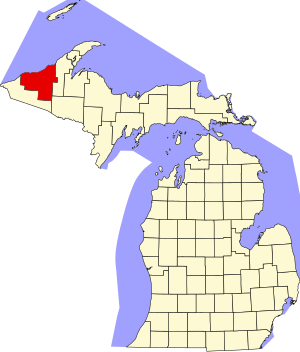
 Location within the U.S. state of Michigan | |
 Michigan's location within the U.S. | |
| Coordinates: 46°59′N 89°16′W / 46.98°N 89.27°W | |
| Country | |
| State | |
| Founded | March 9, 1843 1848 organized[1][2] |
| Named for | Ontonagon River |
| Seat | Ontonagon |
| Largest village | Ontonagon |
| Area | |
• Total | 3,741 sq mi (9,690 km2) |
| • Land | 1,311 sq mi (3,400 km2) |
| • Water | 2,430 sq mi (6,300 km2) 65% |
| Population (2020) | |
• Total | 5,816 |
| • Density | 5.2/sq mi (2.0/km2) |
| Time zone | UTC−5 (Eastern) |
| • Summer (DST) | UTC−4 (EDT) |
| Congressional district | 1st |
| Website | http://ontonagoncounty.org/ |
Ontonagon County (/ˌɒntəˈnɑːɡən/ ON-tə-NAH-gən) is a county in the Upper Peninsula of the U.S. state of Michigan. As of the 2020 census, the population was 5,816,[3] making it Michigan's third-least populous county. The county seat is Ontonagon.[4] The county was set off in 1843, and organized in 1848.[1] Its territory had been organized as part of Chippewa and Mackinac counties. With increasing population in the area, more counties were organized. After Ontonagon was organized, it was split to create Gogebic County.[1][5] It is also the westernmost county in United States that lies within the Eastern Time Zone.


- ^ a b c "Bibliography on Ontonagon County". Clarke Historical Library, Central Michigan University. Retrieved June 29, 2013.
- ^ History :: Houghton County, Michigan Archived January 21, 2011, at the Wayback Machine
- ^ "State & County QuickFacts". US Census Bureau. Retrieved September 15, 2021.
- ^ "Find a County". National Association of Counties. Retrieved June 7, 2011.
- ^ My Michigan, Ontonagon genealogy Archived June 28, 2008, at the Wayback Machine