| Oodnadatta South Australia | |||||||||||||||
|---|---|---|---|---|---|---|---|---|---|---|---|---|---|---|---|
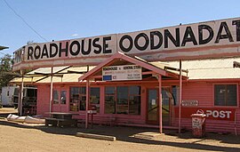
 The Pink Roadhouse at Oodnadatta | |||||||||||||||
| Coordinates | 27°32′53″S 135°26′44″E / 27.54811°S 135.445432°E[1] | ||||||||||||||
| Population | 102 (SAL 2021)[2] | ||||||||||||||
| Established | 30 October 1890 (town) 8 February 2001 (locality)[3][1] | ||||||||||||||
| Postcode(s) | 5734[4] | ||||||||||||||
| Elevation | 121 m (397 ft)(railway station)[5] | ||||||||||||||
| Time zone | ACST (UTC+9:30) | ||||||||||||||
| • Summer (DST) | ACST (UTC+10:30) | ||||||||||||||
| Location |
| ||||||||||||||
| LGA(s) | Pastoral Unincorporated Area[1] | ||||||||||||||
| Region | Far North[1] | ||||||||||||||
| State electorate(s) | Giles[6] | ||||||||||||||
| Federal division(s) | Grey[7] | ||||||||||||||
| |||||||||||||||
| |||||||||||||||
| Footnotes | Locations[1][4] Adjoining localities[1] | ||||||||||||||
Oodnadatta is a small, remote outback town and locality in the Australian state of South Australia, located 1043 kilometres (648 miles) north-north-west of the state capital of Adelaide by road or 873 km (542 mi) direct, at an altitude of 112 metres (367 feet). The unsealed Oodnadatta Track, an outback road popular with tourists, runs through the town.
Town facilities include a hotel, caravan park, post office, general stores, police station, hospital, fuel and minor mechanical repairs. The old railway station now serves as a museum. From the 1880s to the 1930s, Oodnadatta was a base for camel drivers and their animals, which provided cartage when the railway was under construction and along outback tracks before roads were established.[9]
After the railway line was lifted, Oodnadatta's role changed from that of a government service centre and supply depot for surrounding pastoral properties to a residential freehold town for Aboriginal families who, moving from cattle work, bought empty houses as their railway employee occupants left.[9]
- ^ a b c d e f "Search results for 'Oodnadatta, LOCB' with the following datasets: 'Suburbs and Localities', 'Counties', 'Government Towns', 'Local Government Areas', 'SA Government Regions' and 'Gazetteer'". Location SA Map Viewer. Government of South Australian Government. Retrieved 13 May 2018.
- ^ Australian Bureau of Statistics (28 June 2022). "Oodnadatta (suburb and locality)". Australian Census 2021 QuickStats. Retrieved 28 June 2022.
- ^ Bray, J.C. (30 October 1890). "Untitled proclamation (Town of Oodnadatta)" (PDF). The South Australian Government Gazette. South Australian Government. p. 1068. Retrieved 13 May 2018.
- ^ a b "Postcode for Oodnadatta, South Australia". Postcodes Australia. Retrieved 13 May 2018.
- ^ "Search results for 'Oodnadatta Railway Station' with the following datasets selected – 'Suburbs and Localities', 'Government Towns' and 'Gazetteer'". Location SA Map Viewer. Government of South Australian Government. Retrieved 13 May 2018.
- ^ "District of Giles Background Profile". Electoral Commission SA. Retrieved 12 February 2018.
- ^ "Federal electoral division of Grey" (PDF). Australian Electoral Commission. Retrieved 12 February 2018.
- ^ a b c "Oodnadatta Airport Climate Statistics (1939-2024)". Bureau of Meteorology. Retrieved 18 August 2024.
- ^ a b Cite error: The named reference
NRMAwas invoked but never defined (see the help page).
