 | |
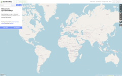
 OpenStreetMap homepage, showing the world map | |
| Available in | 96 languages and variants,[1] local languages for map data |
|---|---|
| Country of origin | United Kingdom |
| Owner | OpenStreetMap Foundation |
| Created by | Steve Coast |
| Products | Editable geographic data, tiled web map layer |
| URL | www |
| Commercial | No |
| Registration | Required for contributors, not required for viewing |
| Users | 10.6 million[2] |
| Launched | 9 August 2004 [3] |
| Current status | Active |
Content license | Open Database License |
| Written in | Ruby, JavaScript |
OpenStreetMap (abbreviated OSM) is a website that uses an open geographic database which is updated and maintained by a community of volunteers via open collaboration. Contributors collect data from surveys, trace from aerial photo imagery or satellite imagery, and also import from other freely licensed geodata sources. OpenStreetMap is freely licensed under the Open Database License and as a result commonly used to make electronic maps, inform turn-by-turn navigation, assist in humanitarian aid and data visualisation. OpenStreetMap uses its own topology to store geographical features which can then be exported into other GIS file formats. The OpenStreetMap website itself is an online map, geodata search engine and editor.
OpenStreetMap was created by Steve Coast in response to the Ordnance Survey, the United Kingdom's national mapping agency, failing to release its data to the public under free licences in 2004. Initially, maps were created only via GPS traces, but it was quickly populated by importing public domain geographical data such as the U.S. TIGER and by tracing imagery as permitted by source. OpenStreetMap's adoption was accelerated by Google Maps's introduction of pricing in 2012 and the development of supporting software and applications.
The database is hosted by the OpenStreetMap Foundation, a non-profit organisation registered in England and Wales and is funded mostly[weasel words] via donations.
- ^ "openstreetmap-website/config/locales at master". Archived from the original on 28 February 2017. Retrieved 30 September 2019 – via GitHub.
- ^ "OpenStreetMap Statistics". OpenStreetMap. OpenStreetMap Foundation. Archived from the original on 13 August 2021. Retrieved 10 November 2023.
- ^ Foody 2017, p. 38.