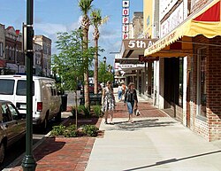
Orangeburg, South Carolina | |
|---|---|
 Central Business District of Orangeburg | |
| Nickname: The Burg | |
 Location in Orangeburg County, South Carolina | |
| Coordinates: 33°29′49″N 80°51′44″W / 33.49694°N 80.86222°W | |
| Country | |
| State | |
| County | Orangeburg |
| Government | |
| • Mayor | Michael C. Butler |
| • City Council | Members |
| Area | |
• Total | 9.02 sq mi (23.36 km2) |
| • Land | 9.01 sq mi (23.34 km2) |
| • Water | 0.01 sq mi (0.02 km2) |
| Elevation | 243 ft (74 m) |
| Population | |
• Total | 13,240 |
| • Density | 1,469.15/sq mi (567.23/km2) |
| Time zone | UTC−5 (EST) |
| • Summer (DST) | UTC−4 (EDT) |
| ZIP codes | 29115-29118 |
| Area code(s) | 803, 839 |
| FIPS code | 45-53080[4] |
| GNIS feature ID | 1249990[2] |
| Website | www.orangeburg.sc.us |


Orangeburg, also known as The Burg, is the principal city in and the county seat of Orangeburg County, South Carolina, United States.[5] The population of the city was 13,964 according to the 2020 census.[6] The city is located 37 miles southeast of Columbia, on the north fork of the Edisto River.
Two historically black institutions of higher education are located in Orangeburg: Claflin University (a liberal arts college) and South Carolina State University (a public university).
- ^ "ArcGIS REST Services Directory". United States Census Bureau. Retrieved October 15, 2022.
- ^ a b U.S. Geological Survey Geographic Names Information System: Orangeburg, South Carolina
- ^ Cite error: The named reference
USCensusDecennial2020CenPopScriptOnlywas invoked but never defined (see the help page). - ^ "U.S. Census website". United States Census Bureau. Retrieved January 31, 2008.
- ^ "Find a County". National Association of Counties. Archived from the original on May 3, 2015. Retrieved June 7, 2011.
- ^ "Orangeburg City Quick Fact". census.gov. U.S. Government. Retrieved July 2, 2022.
