Orderville, Utah | |
|---|---|
 Orderville museum of the Daughters of Utah Pioneers, December 2007 | |
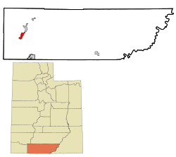
 Location within Kane County and the State of Utah | |
 Location of Utah within the United States | |
| Coordinates: 37°15′44″N 112°39′12″W / 37.26222°N 112.65333°W | |
| Country | United States |
| State | Utah |
| County | Kane |
| Founded | 1875 |
| Incorporated | 1934 |
| Named for | United Order |
| Government | |
| • Mayor | Lyle Goulding |
| Area | |
| • Total | 8.72 sq mi (22.58 km2) |
| • Land | 8.72 sq mi (22.58 km2) |
| • Water | 0.00 sq mi (0.00 km2) |
| Elevation | 5,449 ft (1,661 m) |
| Population (2010) | |
| • Total | 577 |
| • Estimate (2019)[2] | 592 |
| • Density | 67.91/sq mi (26.22/km2) |
| Time zone | UTC-7 (Mountain (MST)) |
| • Summer (DST) | UTC-6 (MDT) |
| ZIP code | 84758 |
| Area code | 435 |
| FIPS code | 49-57080[3] |
| GNIS feature ID | 1431023[4] |
| Website | www |
Orderville is a town in western Kane County, Utah, United States. The population was 577 at the 2010 census.[5] The town was founded and operated under the United Order of the Church of Jesus Christ of Latter-day Saints. This system allowed the community to flourish for some time, but ultimately ended in 1885.[6]
- ^ "2019 U.S. Gazetteer Files". United States Census Bureau. Retrieved August 7, 2020.
- ^ Cite error: The named reference
USCensusEst2019CenPopScriptOnlyDirtyFixDoNotUsewas invoked but never defined (see the help page). - ^ "U.S. Census website". United States Census Bureau. Retrieved January 31, 2008.
- ^ "US Board on Geographic Names". United States Geological Survey. October 25, 2007. Retrieved January 31, 2008.
- ^ "Geographic Identifiers: 2010 Census Summary File 1 (G001), Orderville town, Utah". American FactFinder. U.S. Census Bureau. Archived from the original on February 13, 2020. Retrieved May 21, 2019.
- ^ May, Dean L. "The United Order Movement". Utah History Encyclopedia.