| Oregon Badlands Wilderness | |
|---|---|
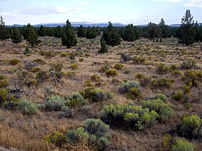
 Oregon Badlands with sagebrush in bloom, Juniper trees, and proximity to Oregon Cascades | |
| Location | Deschutes / Crook counties, Oregon, United States |
| Nearest city | Bend, Oregon |
| Coordinates | 44°00′N 121°02′W / 44°N 121.04°W |
| Area | 29,301 acres (11,858 ha) |
| Established | United States Bureau of Land Management |
The Oregon Badlands Wilderness is a 29,301-acre (11,858 ha) wilderness area located east of Bend in Deschutes and Crook counties in the U.S. state of Oregon. The wilderness is managed by the Bureau of Land Management as part of the National Landscape Conservation System and was created by the Omnibus Public Land Management Act of 2009, which was signed into law by President Barack Obama on 30 March 2009.[1]
The area is known for igneous castle-like rock formations, harsh terrain, ancient Juniper trees, sagebrush, and extensive arid land. Desert wildflowers, dry river canyons, and Native American pictographs can be found.[2] The blind iditarod racer Rachel Scdoris trained in the area,[3] and the wilderness is home to the western terminus of the Oregon Desert Trail.[4][5]
- ^ "Obama signs public lands reform bill". CNN. 30 March 2009. Archived from the original on 31 March 2009. Retrieved 30 March 2009.
- ^ "Badlands Proposed Wilderness". Oregon Natural Desert Association. Retrieved 10 July 2008.
- ^ "Wyden announces wilderness legislation for Badlands in Deschutes County". Press Release of Senator Wyden. U.S. Senate newsroom. 27 May 2008. Retrieved 10 July 2008.
- ^ Morical, Mark (5 June 2013). "Bend hiker hopes to hike trail first". The Bulletin. Bend, Oregon. Retrieved 6 June 2013.
- ^ "Across the Oregon Desert Trail". Oregon Natural Desert Association. Retrieved 6 June 2013.
