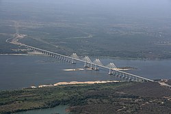
| Orinoco River Río Orinoco | |
|---|---|
 Orinoquia Bridge near Ciudad Guayana, Venezuela | |
 The Orinoco drainage basin | |
| Etymology | Warao for "a place to paddle" |
| Location | |
| Countries | |
| Region | South America |
| Physical characteristics | |
| Source | Hydrological source (main stem) |
| • location | Cerro Delgado-Chalbaud, Parima Mountains, Venezuela |
| • coordinates | 2°19′05″N 63°21′42″W / 2.31806°N 63.36167°W |
| • elevation | 1,047 m (3,435 ft) |
| 2nd source | Geographical source (Orinoco–Guaviare–Guayabero–Papamene–Sorrento) |
| • location | Cordillera Oriental, Colombia |
| • coordinates | 3°31′36.5952″N 74°28′27.3684″W / 3.526832000°N 74.474269000°W |
| • elevation | 3,080 m (10,100 ft) |
| Mouth | Delta Amacuro |
• location | Atlantic Ocean, Venezuela |
• coordinates | 8°37′N 62°15′W / 8.617°N 62.250°W[1] |
• elevation | 0 m (0 ft) |
| Length | 2,140 km (1,330 mi)[2] 2,150 km (1,340 mi)[3] |
| Basin size | 981,446 km2 (378,938 sq mi)[3] to 1,014,797 km2 (391,815 sq mi)[2] |
| Depth | |
| • maximum | 100 m (330 ft) |
| Discharge | |
| • location | Orinoco Delta |
| • average | (Period: 1983–2020)39,000 m3/s (1,400,000 cu ft/s)[2] |
| • minimum | 8,000 m3/s (280,000 cu ft/s)[2] |
| • maximum | 85,000 m3/s (3,000,000 cu ft/s)[2] |
| Discharge | |
| • location | Ciudad Guayana |
| • average | (Period: 1926–2011)37,740 m3/s (1,333,000 cu ft/s)[4] |
| Discharge | |
| • location | Ciudad Bolívar, Venezuela (Basin size: 836,000 km2 (323,000 sq mi)) |
| • average | (Period: 1926–2011)32,760 m3/s (1,157,000 cu ft/s)[4] |
| Discharge | |
| • location | Puerto Ayacucho, Venezuela ( Basin size: 342,000 km2 (132,000 sq mi)) |
| • average | (Period: 1926–2011)16,182 m3/s (571,500 cu ft/s)[4] |
| Discharge | |
| • location | Masagua, Colombia (Basin size: 101,000 km2 (39,000 sq mi)) |
| • average | (Period: 1926–2011)4,400 m3/s (160,000 cu ft/s); Tama Tama, Venezuela (Basin size: 37,870 km2 (14,620 sq mi) 1,400 m3/s (49,000 cu ft/s) |
| Basin features | |
| Progression | Atlantic Ocean |
| River system | Orinoco River |
| Tributaries | |
| • left | Casiquiare, Guaviare, Vichada, Tomo, Cinaruco, Capanaparo, Meta, Arauca, Apure, Guárico |
| • right | Mavaca, Sipapo, Ocamo, Ventuari, Suapure, Parguaza, Caura, Cuchivero, Aro, Caroní |
 | |
The Orinoco (Spanish pronunciation: [oɾiˈnoko]) is one of the longest rivers in South America at 2,140 km (1,330 mi).[2]
Its drainage basin, sometimes known as the Orinoquia,[5] covers ca 1 million km2, with 65% of it in Venezuela and the 35% in Colombia. It is the fourth largest river in the world by discharge volume of water. The nevertheless high volume flow (39,000 m3/s at delta) of the Orinoco can be explained by the high precipitation in almost the entire catchment area (ca 2,300 mm/a). The Orinoco River and its tributaries are the major transportation system for eastern and interior Venezuela and the Llanos of Colombia. The environment and wildlife in the Orinoco's basin are extremely diverse.[2][6][7][8]
- ^ Orinoco River at GEOnet Names Server
- ^ a b c d e f g Carlos Andrés, Lasso Alcalá; Mónica Andrea, Morales Betancourt (2022). XXI. PECES DEL FONDO DEL RÍO ORINOCO Y AFLUENTES PRINCIPALES (COLOMBIA-VENEZUELA): diversidad y aspectos bioecológicos. doi:10.21068/eh9789585183629. ISBN 978-958-5183-65-0.
- ^ a b "Orinoco River Basin, South America" (PDF). 2016.
- ^ a b c José Rafael, Córdova; Marcelo González, Sanabria. "La geografía del agua" (PDF).
- ^ "Orinoquia, Orinoquía". Diccionario panhispánico de dudas. Royal Spanish Academy. 2005. Retrieved 2023-01-07.
- ^ Supplement of Lehmann, Fanny; Vishwakarma, Bramha Dutt; Bamber, Jonathan (2021). "How well are we able to close the water budget at the global scale?" (PDF). Hydrology and Earth System Sciences. 26: 35–54. doi:10.5194/hess-26-35-2022. Archived (PDF) from the original on 4 January 2022. Retrieved 21 February 2022.
- ^ "Orinoco River Basin, South America–WWF".
- ^ "Publications-EcoHealth Report Cards".
