| Scottish Gaelic name | Eilean Iarmain |
|---|---|
| Old Norse name | Örfirirsey |
| Meaning of name | "Ebb (i.e. tidal) island", from Norse |
| Location | |
| OS grid reference | NG709125 |
| Coordinates | 57°09′N 5°47′W / 57.15°N 5.79°W |
| Physical geography | |
| Island group | Inner Hebrides |
| Area | 35 ha (86 acres) |
| Highest elevation | 46 m (151 ft) |
| Administration | |
| Council area | Highland |
| Country | Scotland |
| Sovereign state | United Kingdom |
| Demographics | |
| Population | 0 |
| References | [1][2][3][4] |
| Ornsay Lighthouse Isleornsay Eilean Iarmain | |
 Ornsay Lighthouse | |
| Coordinates | 57°08′36″N 5°46′52″W / 57.143434°N 5.781037°W |
| Constructed | 1857 |
| Built by | Thomas Stevenson, David Stevenson |
| Construction | masonry tower |
| Automated | 1962 |
| Height | 19 m (62 ft) |
| Shape | cylindrical tower with balcony and lantern |
| Markings | white tower, black lantern, ochre trim |
| Power source | mains electricity |
| Operator | Northern Lighthouse Board[5][6] |
| Heritage | category B listed building |
| Focal height | 18 m (59 ft) |
| Lens | 300 mm (12 in) acrylic lens with a 250 W tungsten lamp |
| Range | 12 nmi (22 km) |
| Characteristic | Oc W 8 s |
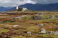
Ornsay is a small tidal island to the east of the Sleat peninsula on the Isle of Skye in the Inner Hebrides of Scotland.
- ^ 2001 UK Census per List of islands of Scotland
- ^ Haswell-Smith, Hamish (2004). The Scottish Islands. Edinburgh: Canongate. ISBN 978-1-84195-454-7.
- ^ Ordnance Survey
- ^ Iain Mac an Tailleir. "Placenames" (PDF). Pàrlamaid na h-Alba. Retrieved 27 July 2007.
- ^ Rowlett, Russ. "Lighthouses of Scotland: Highlands". The Lighthouse Directory. University of North Carolina at Chapel Hill. Retrieved 20 May 2016.
- ^ Ornsay Archived 2016-03-05 at the Wayback Machine Northern Lighthouse Board. Retrieved 20 May 2016
